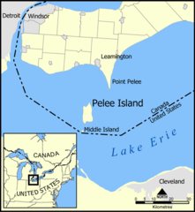
Pelee (Ontario)
 | |
| Państwo | |
|---|---|
| Prowincja | Ontario |
| Hrabstwo | Essex |
| Powierzchnia | 41,84 km² |
| Populacja (2001) • liczba ludności • gęstość | 256 6,12 os./km² |
 | |
| Portal | |
Pelee – gmina (ang. township) w Kanadzie, w prowincji Ontario, w hrabstwie Essex.
Powierzchnia Pelee to 41,84 km². Według danych spisu powszechnego z roku 2001 Pelee liczy 256 mieszkańców (6,12 os./km²).
Na wyspach jeziora Erie utworzono obszar Pelee Island Natural Areas, istotny dla całej biosfery ze względu na rolę w wędrówkach ptaków[1].
Przypisy
- ↑ Pelee Island Natural Areas Southwest Lake Erie, Ontario (ang.). W: Strona internetowa Important Bird Area (IBA) [on-line]. Bird Studies Canada. [dostęp 2019-11-05].
Media użyte na tej stronie
Autor: NordNordWest, Licencja: CC BY-SA 3.0
Location map of Ontario, Canada
Autor: Autor nie został podany w rozpoznawalny automatycznie sposób. Założono, że to NormanEinstein (w oparciu o szablon praw autorskich)., Licencja: CC-BY-SA-3.0
A map showing Pelee Island, Middle Island, and Point Pelee as well as the nearby communities of Leamington, Windsor, Detroit, and Cleveland.
Created by NormanEinstein, May 11, 2005.Autor:
- Canada location map.svg:
- derivative work: Yug (talk)
- Canada (geolocalisation).svg: STyx
- derivative work: Malarz pl
modification of File:Canada location map.svg, with 5px added on south to make a place for en:Pelee, Ontario


