Pello
 | |||
| |||
| Państwo | |||
|---|---|---|---|
| Region | |||
| Podregion | |||
| Powierzchnia | 1863,69 km² | ||
| Populacja (31.12.2021) • liczba ludności |
| ||
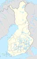
Położenie na mapie Finlandii (c) Karte: NordNordWest, Lizenz: Creative Commons by-sa-3.0 de | |||
| Strona internetowa | |||
| Portal | |||
Pello – gmina w Finlandii, położona w północnej części kraju, należąca do regionu Laponia, podregionu Torniolaakso.
Przypisy
- ↑ Väestö 31.12. muuttujina Alue, Ikä, Sukupuoli, Vuosi ja Tiedot, Tilastokeskus [dostęp 2022-10-18] [zarchiwizowane z adresu 2022-10-18] (fiń.).
Media użyte na tej stronie
Flag of Finland.svg
Flaga Finlandii
Flaga Finlandii
Lapin maakunnan vaakuna.svg
Coat of arms of Laponia, Finland
Coat of arms of Laponia, Finland
Finland adm location map.svg
(c) Karte: NordNordWest, Lizenz: Creative Commons by-sa-3.0 de
Location map of Finland
(c) Karte: NordNordWest, Lizenz: Creative Commons by-sa-3.0 de
Location map of Finland
Pellon vaakuna.svg
On blue field a triple mountain and above of it three six-spiked stars positioned 1+2; all silver.
On blue field a triple mountain and above of it three six-spiked stars positioned 1+2; all silver.
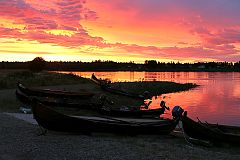
Tornionjoki-Pello.jpg
Autor: Arto Alanenpää, Licencja: CC BY-SA 4.0
Tornionjoki is a river between Swedish and Finnish borders. Picture from the vilage of Pello, Lappland.
Autor: Arto Alanenpää, Licencja: CC BY-SA 4.0
Tornionjoki is a river between Swedish and Finnish borders. Picture from the vilage of Pello, Lappland.


