Pembrokeshire
| hrabstwo | |||||
(c) Andy F, CC BY-SA 2.0 | |||||
| |||||
| Dewiza: Ex Unitate Vires (łacina: Siła z jedności) | |||||
| Państwo | |||||
|---|---|---|---|---|---|
| Księstwo | |||||
| Siedziba | |||||
| Powierzchnia | 1 590 km² | ||||
| Populacja • liczba ludności |
| ||||
| • gęstość | 74 os./km² | ||||
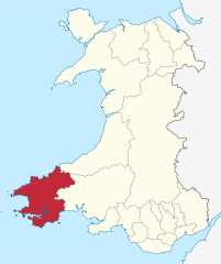
Położenie na mapie Walii | |||||
| Portal | |||||
Pembrokeshire (wal. Sir Benfro) – hrabstwo w południowo-zachodniej Walii, na półwyspie Pembroke. Graniczy od wschodu z hrabstwami Ceredigion i Carmarthenshire. Stolicą hrabstwa jest Haverfordwest.
Wzdłuż wybrzeża hrabstwa rozciąga się park narodowy Pembrokeshire Coast.
Miejscowości
Na terenie hrabstwa znajdują się następujące miejscowości[1][2] (w nawiasach liczba ludności w 2011[3]):
- Haverfordwest (14 596)
- Milford Haven (13 582)
- Pembroke Dock (9753)
- Pembroke (7552)
- Tenby (4696)
- Neyland (3708)
- Fishguard (3419)
- Saundersfoot (2767)
- Narberth (2265)
- Johnston (1941)
- Goodwick (1720)
- St David’s (1408)
- Letterston (1245)
- Pentlepoir (1211)
- Kilgetty (1207)
- St Dogmaels (1117)
- Broad Haven (880)
- Llangwm (875)
- Cilgerran (865)
- Sageston (857)
- Newport (851)
- Penally (848)
- Hook (838)
- Cosheston (828)
- Dinas Cross (815)
- Begelly (761)
- St Florence (756)
- Maenclochog (731)
- Solva (710)
- Crymych (704)
- Clunderwen (677)
- Hill Mountain (673)
- Jameston (634)
- Templeton (627)
- Brawdy (620)
- Stepaside (619)
- Rosemarket (613)
- New Hedges (594)
- Lamphey (593)
- Crundale (584)
- Llandissilio (513)
- Spittal (494)
- St Ishmael's (478)
- Roch (463)
- Hundleton (435)
- Tavernspite (349)
- Waterston (335)
- Keeston (324)
- Clarbeston Road (318)
- Freshwater East (250)
Mapa
Przypisy
- ↑ a b Office for National Statistics: Built-up Area to Local Authority District (December 2011) Lookup in England and Wales (ang.). W: Open Geography Portal [on-line]. [dostęp 2022-06-05].
- ↑ a b Office for National Statistics: Built-up Area Sub Divisions (December 2011) Boundaries (ang.). W: Open Geography Potal [on-line]. [dostęp 2022-06-05].
- ↑ a b Office for National Statistics: KS101EW - Usual resident population (ang.). W: 2011 Census [on-line]. Nomis – Official labour market statistics, 2013-02-12. [dostęp 2022-06-05].
Media użyte na tej stronie
Autor: TUBS
Location of unitary authority area Pembrokeshire in Wales in Wales.
(c) Andy F, CC BY-SA 2.0
Circular walk from Solva to St Elvis and Dinas Fawr (25) This series of photos portrays a 2-mile circular walk east and south of Solva, Pembrokeshire.
Initially, the walk climbs out of the valley of the River Solva onto The Gribbin, a knife-edge ridge between the glacial valleys of Solva and Gwadn. The walk then descends to a marshy area before climbing inland to farmland. Near St Elvis Farm, the walk passes a cromlech (a neolithic burial chamber) then heads to the coastpath and turns west to follow the clifftop. After descending into Gwadn cove, the walk climbs to rejoin The Gribbin before descending into Solva. The route can be followed on OS 1:50000 sheet 157 or on OS 'Explorer' 1:25000 sheet OL35.
The walk follows the coastpath along the clifftop west towards Solva. There are several gates along this stretch and the path is well signposted. However, walkers should be cautious as the cliff edge is not fenced off and, in places, is precipitous.
This photo is looking back (eastward) along the coastpath to Dinas Fawr headland. There is a public right of way out to the tip of the headland but it is a precipitous path and suitable only for sure-footed walkers.
Previous [1]
Next [2]Contains Ordnance Survey data © Crown copyright and database right, CC BY-SA 3.0
Blank map of Pembrokeshire, UK with the following information shown:
- Administrative borders
- Coastline, lakes and rivers
- Roads and railways
- Urban areas
Equirectangular map projection on WGS 84 datum, with N/S stretched 160%
Geographic limits:
- West: 5.70W
- East: 4.45W
- North: 52.15N
- South: 51.55N
Autor: Peter Stock. Vectorized by Magasjukur2, Licencja: CC0
Flag of Pembrokeshire


