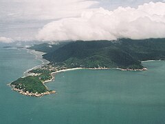
Phangan
 wyspa Phangan | |
| Kontynent | Azja |
|---|---|
| Państwo | |
| Akwen | Morze Południowochińskie |
| Powierzchnia | 168 km² |
| Populacja • liczba ludności | 11 846 |
Phangan – tajska przybrzeżna wyspa w południowo-wschodniej części Zatoki Tajlandzkiej. Jej powierzchnia wynosi 168 km², jest wyspą równinną, jedynie miejscami posiada wzniesienia (627 m n.p.m.)[1].
Ludność wyspy zajmuje się rybołówstwem oraz uprawą palmy kokosowej[1].
Przypisy
- ↑ a b Phangan, [w:] Encyklopedia PWN [online] [dostęp 2021-04-18].
Linki zewnętrzne
Media użyte na tej stronie
The national flag of Kingdom of Thailand since September 2017; there are total of 3 colours:
- Red represents the blood spilt to protect Thailand’s independence and often more simply described as representing the nation.
- White represents the religion of Buddhism, the predominant religion of the nation
- Blue represents the monarchy of the nation, which is recognised as the centre of Thai hearts.
Autor: Manfred Werner (User:Tsui, Licencja: CC-BY-SA-3.0
Koh Phangan (Surat Thani, Thailand). Seen from Southeast.
In front is the southern tip of the island (Laem Haad Rin), connected with the main island by the isthmus Haad Rin. Especially the eastern beach of the isthmus, Haad Rin Nok, the long white coastal part in the middle of the picture, is famous for its Full Moon Parties.
To the left are, from bottom to top, the bays Ban Kai, Ban Tai and Bang Charu, with the small island Ko Tae Nai at the left horizon. To the right is the bay Haad Yuan.


