Pico-Chick Hearn
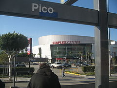
 Widok na Staples Center ze stacji Pico-Chick Hearn | |
| Państwo | |
|---|---|
| Data otwarcia | 14 lipca 1990 |
| Poprzednia stacja | |
| Następna stacja | Grand (niebieska linia) |
| Portal | |
Pico-Chick Hearn – naziemna stacja niebieskiej linii i linii Expo metra w Los Angeles oraz linii srebrnej bus rapid transit w systemie Metro Liner znajdująca się na rogu Flower Street i Pico Boulevard. Drugi człon nazwy upamiętnia Francisa Dayle’a „Chick” Hearna, wieloletniego spikera na meczach Los Angeles Lakers, który to zespół w pobliskim Staples Center rozgrywa swoje mecze.
Godziny kursowania
Tramwaje kursują codziennie od około godziny 5.00 do 0.45[1][2]
Miejsca użyteczności publicznej i atrakcje turystyczne
W pobliżu znajdują się:
- Staples Center
- Chick Hearn Court/L.A. Live
- Los Angeles Convention Center
- Circa Complex
- Fashion Institute of Design & Merchandising, Los Angeles Campus
- California Hospital Medical Center
- Pico-Union, Los Angeles, California
Zobacz też
Przypisy
- ↑ Line 801 – Metro Rail Blue Line (Los Angeles – Long Beach). metro.net. [zarchiwizowane z tego adresu (2010-06-21)]..
- ↑ http://media.metro.net/riding_metro/bus_overview/images/806.pdf
Linki zewnętrzne
- Mapa połączeń. metro.net. [zarchiwizowane z tego adresu (2012-02-25)].
- Metro Expo Line Construction Authority. buildexpo.org. [zarchiwizowane z tego adresu (2012-12-10)].
- Projekt budowy pierwszego odcinka linii Expo Line do Culver City
- OpenStreetMap
Media użyte na tej stronie
Autor: Uwe Dedering, Licencja: CC BY-SA 3.0
Location map of the USA (without Hawaii and Alaska).
EquiDistantConicProjection:
Central parallel:
* N: 37.0° N
Central meridian:
* E: 96.0° W
Standard parallels:
* 1: 32.0° N
* 2: 42.0° N
Made with Natural Earth. Free vector and raster map data @ naturalearthdata.com.
Formulas for x and y:
x = 50.0 + 124.03149777329222 * ((1.9694462586094064-({{{2}}}* pi / 180))
      * sin(0.6010514667026994 * ({{{3}}} + 96) * pi / 180))
y = 50.0 + 1.6155950752393982 * 124.03149777329222 * 0.02613325650382181
      - 1.6155950752393982  * 124.03149777329222 *
     (1.3236744353715044  - (1.9694462586094064-({{{2}}}* pi / 180))
      * cos(0.6010514667026994 * ({{{3}}} + 96) * pi / 180))
Autor: NordNordWest, Licencja: CC BY 3.0
Location map of California, USA
The flag of Navassa Island is simply the United States flag. It does not have a "local" flag or "unofficial" flag; it is an uninhabited island. The version with a profile view was based on Flags of the World and as a fictional design has no status warranting a place on any Wiki. It was made up by a random person with no connection to the island, it has never flown on the island, and it has never received any sort of recognition or validation by any authority. The person quoted on that page has no authority to bestow a flag, "unofficial" or otherwise, on the island.
Autor: Hbdragon88, Licencja: CC BY-SA 2.5
Photo of the Pico station on the Blue Line with the Staples CEnter in the background
Autor: Alexrk2, Licencja: CC BY 3.0
Ta mapa została stworzona za pomocą GeoTools.
The icon for the Metro A line.
Red Line circle.
Silver Line square (for Los Angeles Metro).
A specific Metro line identifier.
Purple Line circle.
An Expo Line test train rests at the La Cienega station, with the downtown L.A. skyline in the distance.
Autor:
Oryginalnym przesyłającym był DaveofCali z angielskiej Wikipedii
Blue Line train at the Imperial / Wilmington station


