Pieter Lenie Station
| ||
 Pieter Lenie Field Station | ||
| Przynależność państwowa | ||
| Data założenia | 1985 | |
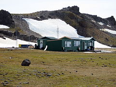
Pieter J. Lenie Field Station, zw. Copacabana – zał. w 1985 amerykańska, letnia stacja antarktyczna, położona na Wyspie Króla Jerzego (ok. 2 km w linii prostej na SE od Polskiej Stacji Antarktycznej im. Henryka Arctowskiego). Składa się z trzech niewielkich budynków położonych u podnóża Wzgórz Ratowników, niedaleko Przylądka Llano. Stacja znajduje się na terenie Szczególnie Chronionego Obszaru Antarktyki "Zachodni brzeg Zatoki Admiralicji" (ASPA 128).
Media użyte na tej stronie
Autor: Alexrk2, Licencja: CC BY-SA 3.0
Location map Antarctica, Azimuthal equidistant projection
The flag of Navassa Island is simply the United States flag. It does not have a "local" flag or "unofficial" flag; it is an uninhabited island. The version with a profile view was based on Flags of the World and as a fictional design has no status warranting a place on any Wiki. It was made up by a random person with no connection to the island, it has never flown on the island, and it has never received any sort of recognition or validation by any authority. The person quoted on that page has no authority to bestow a flag, "unofficial" or otherwise, on the island.
Blank SVG map of King George Island
Autor: Acaro, Licencja: CC BY-SA 3.0
Copacabana field Hut, King George Island, South Shetlands
Autor: NordNordWest, Licencja: CC BY-SA 3.0
Location map of the South Shetland Islands


