Pilbara
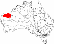
Pilbara – region w Australii, w północnej części stanu Australia Zachodnia, leżący nad Oceanem Indyjskim, pomiędzy rzekami De Grey i Ashburton. Dla potrzeb statystycznych region zdefiniowany jest jako obejmujący cztery jednostki administracyjne: Ashburton, East Pilbara, Port Hedland oraz Roebourne. Powierzchnia regionu wynosi ok. 510 000 km², a liczba ludności 42 411 (2001).
W regionie znajdują się liczne złoża, m.in. złota, cyny, miedzi, talku, manganu, magnezu, srebra, berylu i kolumbitu.
Bibliografia
- Pilbara, [w:] Encyclopædia Britannica [online] [dostęp 2011-08-08] (ang.).
Media użyte na tej stronie
(c) Yewenyi z angielskojęzycznej Wikipedii, CC-BY-SA-3.0
Photo taken north of the Pilbara looking at the range.
Autor: Autor nie został podany w rozpoznawalny automatycznie sposób. Założono, że to Roke~commonswiki (w oparciu o szablon praw autorskich)., Licencja: CC-BY-SA-3.0
Pilbara in Western Australia, i made the image. My son Richard Hekimian (Archeologist) observing in the Pilbara region starting from 4th of November 2009,in a hard climate condition but enjoying every moment of it.
Autor: Hesperian, Licencja: CC-BY-SA-3.0
This is a map of the Interim Biogeographic Regionalisation of Australia (IBRA), with state boundaries overlaid. The Pilbara region is shown in red.


