Plaka
| ||||
| ||||
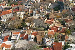
 Widok na Plakę z Akropolu | ||||
| Państwo | ||||
| Miasto | Ateny | |||
Położenie na mapie Grecji (c) Lencer, CC BY-SA 3.0 | ||||
Plaka (gr. Πλάκα) - historyczna część Aten, usytuowana u stóp Akropolu ponad starożytną agorą. Znajdują się tam XVIII-wieczne kamienice, kręte uliczki, restauracje i sklepy z pamiątkami. Zabytkowe budynki w tej części miasta stoją często na fundamentach pamiętających jeszcze czasy starożytności. Na Place działa też kilka muzeów.
Zobacz też
Media użyte na tej stronie
(c) Lencer, CC BY-SA 3.0
Location map of Greece
Equirectangular projection, N/S stretching 120 %. Geographic limits of the map:
- N: 42.0° N
- S: 34.6° N
- W: 19.1° E
- E: 29.9° E
Autor: David Dennis, Licencja: CC BY-SA 2.0
Athenian Rooftops:I took this shot in the morning from the Acropolis in Athens, Greece. I saturated the image a bit to make it look like it did to my eye.
Autor: OpenStreetMap contributors, Licencja: CC BY-SA 2.0
OpenStreetMap map of Athens, Greece, intended for use in geolocation templates.
- top = 38.151
- bottom = 37.858
- left = 23.556
- right = 23.897


