Plymouth
 | |||
| |||
| Państwo | |||
|---|---|---|---|
| Kraj | |||
| Region | |||
| Hrabstwo ceremonialne | |||
| Unitary authority | |||
| Populacja (2001) • liczba ludności |
| ||
| Nr kierunkowy | 01752 | ||
| Kod pocztowy | PL1-PL9 | ||
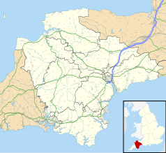
Położenie na mapie Devonu Contains Ordnance Survey data © Crown copyright and database right, CC BY-SA 3.0 | |||
Położenie na mapie Wielkiej Brytanii (c) Karte: NordNordWest, Lizenz: Creative Commons by-sa-3.0 de | |||
| Strona internetowa | |||
| Portal | |||
Plymouth (wym. /ˈplɪməθ/, korn. Aberplymm) – jeden z największych portów Wielkiej Brytanii, położony nad rzeką Plym i Tamar, na granicy między Kornwalią a Devonem, w dystrykcie (unitary authority) Plymouth. Port nad kanałem La Manche. W 1967 przyłączono do miasta przedmieścia Plympton i Plymstock.
W 2001 roku miasto liczyło 243 795 mieszkańców[1].
Miasto zbudowane zostało nad jednym z największych naturalnych portów na świecie. Plymouth jest jednym z największych miast na południowym wybrzeżu Wielkiej Brytanii. W mieście znajduje się wiele zabytkowych kamienic i pozostałości z czasów jego świetności.
Gospodarka
W mieście rozwinął się przemysł stoczniowy, maszynowy, metalowy, elektrotechniczny, precyzyjny, chemiczny, obuwniczy, odzieżowy oraz spożywczy[2].
Urodzeni w Plymouth
- William Bligh – oficer marynarki brytyjskiej, gubernator Nowej Południowej Walii
- Tom Daley – sportowiec specjalizujący się w skokach do wody, zdobywca brązowego medalu na Igrzyskach Olimpijskich w Londynie
Miasta partnerskie
Przypisy
- ↑ Collins Dictionary
- ↑ Plymouth, [w:] Encyklopedia PWN [online] [dostęp 2021-08-05].
Media użyte na tej stronie
(c) Karte: NordNordWest, Lizenz: Creative Commons by-sa-3.0 de
Location map of the United Kingdom
Flag of England. Saint George's cross (a red cross on a white background), used as the Flag of England, the Italian city of Genoa and various other places.
Autor: Pedro A. Gracia Fajardo, escudo de Manual de Imagen Institucional de la Administración General del Estado, Licencja: CC0
Flaga Hiszpanii
The flag of Navassa Island is simply the United States flag. It does not have a "local" flag or "unofficial" flag; it is an uninhabited island. The version with a profile view was based on Flags of the World and as a fictional design has no status warranting a place on any Wiki. It was made up by a random person with no connection to the island, it has never flown on the island, and it has never received any sort of recognition or validation by any authority. The person quoted on that page has no authority to bestow a flag, "unofficial" or otherwise, on the island.
Autor: Mark.murphy took this picture and this image was cropped by bsrboy., Licencja: CC BY 3.0
A cropped image of Plymouth Hoe
Contains Ordnance Survey data © Crown copyright and database right, CC BY-SA 3.0
Map of Devon, UK with the following information shown:
- Administrative borders
- Coastline, lakes and rivers
- Motorways and primary routes
- Urban areas
Equirectangular map projection on WGS 84 datum, with N/S stretched 150%
Geographic limits:
- West: 4.72W
- East: 2.86W
- North: 51.3N
- South: 50.16N
Autor: Lobsterthermidor (dyskusja) 22:53, 23 September 2017 (UTC), Licencja: CC BY-SA 3.0
Arms of the Corporation of the City of Plymouth in Devon, England: Argent, a saltire vert between four towers sable


