Podprefektura Ogasawara
| |||||||
| podprefektura | |||||||
 | |||||||
| Państwo | |||||||
|---|---|---|---|---|---|---|---|
| Prefektura | |||||||
| Powierzchnia | 106,88[1] km² | ||||||
| Populacja (2020) • liczba ludności |
| ||||||
| • gęstość | 27,4 os./km² | ||||||
| Kod pocztowy | 100-2101 | ||||||
Adres urzędu: Nichi-machi, Chichi-jima, Ogasawara-mura, Tōkyō-to | |||||||
| Plan | |||||||
 | |||||||
| 27°05′44″N 142°11′28″E/27,095661 142,191042 | |||||||
| Strona internetowa | |||||||
| Portal | |||||||
Podprefektura Ogasawara (jap. 小笠原支庁 Ogasawara-shichō) – podprefektura w Japonii, w prefekturze metropolitarnej Tokio. W skład podprefektury wchodzi wioska Ogasawara[3]. Ma powierzchnię 106,88 km2 [1]. W 2020 r. mieszkały w niej 2 932 osoby, w 1 469 gospodarstwach domowych[2] (w 2010 r. 2 783 osoby, w 1 347 gospodarstwach domowych)[4].
Zobacz też
- Oficjalna strona podprefektury
- Informacja turystyczna. ogasawaramura.com. [zarchiwizowane z tego adresu (2017-05-28)].
Przypisy
- ↑ a b Geospatial Information Authority of Japan 2021 ↓, s. 28.
- ↑ a b Statistics Bureau of Japan 2021 ↓.
- ↑ Ogasawara (jap.). Tokyo Metropolitan Ogasawara Island Branch Office. [dostęp 2017-07-01].
- ↑ Statistics Bureau of Japan 2011 ↓, s. 25.
Bibliografia
- Geospatial Information Authority of Japan: 令和3年 全国都道府県市区町村別面積調 (1月1日時点) (Reiwa 3rd year Area adjustment by prefecture, city, ward, town, and village (As of January 1)) (jap.). gsi.go.jp, 2021. [dostęp 2021-10-31]. [zarchiwizowane z tego adresu (2021-06-05)].
- Statistics Bureau, Ministry of Internal Affairs and Communications: Preliminary Counts of the Population and Households (ang.). W: 2020 Population Census [on-line]. e-stat.go.jp Portal Site of Official Statistics of Japan, 2021. [dostęp 2021-10-31].
- 平成22年国勢調査 – 人口速報集計結果 (2010 Census - Population Bulletin Aggregation Results) (jap.). e-stat.go.jp Portal Site of Official Statistics of Japan, 2011. [dostęp 2021-10-31].
Media użyte na tej stronie
Autor: Yasu (dyskusja), Licencja: CC BY-SA 3.0
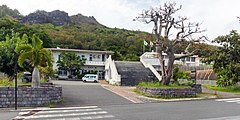
Tokyo Metropolitan Government Ogasawara Island Branch Office in Chichijima, Ogasawara
Autor: Tentotwo, Licencja: CC BY-SA 3.0
Location map of Pacific Ocean.
- Projection: Lambert azimuthal equal-area projection.
- Area of interest:
- N: 60.0° N
- S: -80.0° N
- W: -260.0° E
- E: -70.0° E
- Projection center:
- NS: -10.0° N
- WE: -165.0° E
- GMT projection: -JA-165.0/-10.0/180/19.998266666666666c
- GMT region: -R-320.2519138145009/-12.459450078533589/-5.473602099069988/26.40516525873812r
- Land and shoreline: 1:110m Natural Earth Datasets, borders 1:50m
Autor: Lincun, Licencja: CC BY-SA 3.0
Location of Ogasawara Village in Tokyo Prefecture
東京都旗。1964年(昭和39年)10月1日制定。
Symbol flag of Tokyo Metropolis


