Podział administracyjny Jamajki
| JamajkaTen artykuł jest częścią serii: Ustrój i polityka Jamajki Ustrój polityczny Konstytucja Monarcha Władza ustawodawcza Władza wykonawcza Władza sądownicza Kontrola państwowa Finanse Samorząd terytorialny Partie polityczne Wybory Polityka zagraniczna Wikiprojekt Polityka |
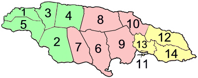
Jamajka jest podzielona na 3 hrabstwa, a te na 14 regionów (gmin).
- Hrabstwo Cornwall (stolica Montego Bay) – zielony
- Hrabstwo Middlesex (stolica Spanish Town) – różowy
- Hrabstwo Surrey (stolica Kingston) – żółty
Podział
| Region | Obszar km² | Populacja 2001 | Stolica | |
| Hrabstwo Cornwall | ||||
| 1 | Hanover | 450,4 | 67 037 | Lucea |
| 2 | Saint Elizabeth | 1 212,4 | 146 404 | Black River |
| 3 | Saint James | 594,9 | 175 127 | Montego Bay |
| 4 | Trelawny | 874,6 | 73 066 | Falmouth |
| 5 | Westmoreland | 807,0 | 138 947 | Savanna-la-Mar |
| Hrabstwo Middlesex | ||||
| 6 | Clarendon | 1 196,3 | 237 024 | May Pen |
| 7 | Manchester | 830,1 | 185 801 | Mandeville |
| 8 | Saint Ann | 1 212,6 | 166 762 | Saint Ann’s Bay |
| 9 | Saint Catherine | 1 192,4 | 482 308 | Spanish Town |
| 10 | Saint Mary | 610,5 | 111 466 | Port Maria |
| Hrabstwo Surrey | ||||
| 11 | Kingston | 21,8 | 96 052 | Kingston |
| 12 | Portland | 814,0 | 80 205 | Port Antonio |
| 13 | Saint Andrew | 430,7 | 555 828 | Half Way Tree |
| 14 | Saint Thomas | 742,8 | 91 604 | Morant Bay |
| Jamajka | 10 990,5 | 2 607 631 | Kingston | |
Historia
Parafie były elementem administracji lokalnej na Jamajce odkąd wyspa została podbita przez Anglię w 1655. Od początku historii Jamajka miała pewną liczbę parafii, z których część obecnie nie istnieje (obecnie zostały włączone w istniejące parafie, bądź rozdzielone między sąsiadujące parafie). Najwięcej parafii było w 1865, Jamajka miała ich 22 (aktualne 14 plus wymienione na poniższej liście). Aktualny wykaz parafii został ustalony w 1867 przez eliminację 8 parafii.
Lista zlikwidowanych parafii według hrabstw:
- Port Royal (został podzielony między Kingston i Saint Andrew)
- Saint George (został podzielony między Saint Mary i Portland)
- Saint David (teraz część parafii Saint Thomas)
- Metcalfe (teraz część Saint Mary)
- Saint Dorothy (teraz część Saint Catherine)
- Saint John (teraz część Saint Catherine)
- Saint Thomas w Vale (teraz część Saint Catherine)
- Vere (teraz część Clarendon)
Media użyte na tej stronie
Flag of Jamaica. “The sunshine, the land is green, and the people are strong and bold” is the symbolism of the colours of the flag. GOLD represents the natural wealth and beauty of sunlight; GREEN represents hope and agricultural resources; BLACK represents the strength and creativity of the people. The original symbolism, however, was "Hardships there are, but the land is green, and the sun shineth", where BLACK represented the hardships being faced.
Autor: user:ranas, Licencja: CC BY-SA 2.5
Parishes and counties of Jamaica alternative numeration


