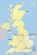
Podział administracyjny Wielkiej Brytanii
| Wielka BrytaniaTen artykuł jest częścią serii: Ustrój i polityka Wielkiej Brytanii Ustrój polityczny Konstytucja Władza ustawodawcza Monarcha Władza wykonawcza Władza sądownicza Kontrola państwowa Finanse Samorząd terytorialny Partie polityczne Wybory Polityka zagraniczna | |
| Portal |
Podział administracyjny Wielkiej Brytanii:
Wielka Brytania podzielona jest na dwa kraje: Anglię i Szkocję; jedno księstwo: Walię; jedną prowincję: Irlandię Północną[1][2]. Szczegółowy podział administracyjny nie jest ustalony przez rząd centralny, lecz samodzielnie w każdej z części, więc pomiędzy częściami istnieją duże różnice w organizacji administracji samorządowej:
 W Anglii nie ma dualizmu administracji terytorialnej, czyli występowania obok siebie administracji rządowej i samorządowej. Rząd zajmuje się sprawami całego kraju. Istnieje podział na regiony, hrabstwa, dystrykty i parafie (parish) (zob. podział administracyjny Anglii).
 Irlandia Północna od 1973 podzielona jest na dystrykty – początkowo 26, a od 2015 roku jedenaście (zob. podział administracyjny Irlandii Północnej).
 Szkocja od 1996 dzieli się na 32 hrabstwa (zob. podział administracyjny Szkocji).
 Walia również w 1996 podzielona została na 22 jednostki administracyjne: 9 hrabstw, 10 hrabstw miejskich i 3 miasta, wszystkie o równym statusie (zob. podział administracyjny Walii).
Przypisy
- ↑ Permanent Committee on Geographical Names for British Official Use, Ordnance Survey of Great Britain: Report of the United Kingdom of Great Britain and Northern Ireland, par. "Geopolitical terminology (ang.). [dostęp 2015-01-18].
- ↑ International Organization for Standardization: ISO 3166-2 NEWSLETTER, par. UNITED KINGDOM (ang.). [dostęp 2008-02-07].
| ||||||||||
Media użyte na tej stronie
Flag of England. Saint George's cross (a red cross on a white background), used as the Flag of England, the Italian city of Genoa and various other places.
Ulster Banner is a heraldic banner taken from the former coat of arms of Northern Ireland. It was used by the Northern Ireland government in 1953-1973 with Edwardian crown since coronation of Queen Elizabeth II, based earlier design with Tudor Crown from 1924. Otherwise known as the Ulster Flag, Red Hand of Ulster Flag, Red Hand Flag.
Autor: Maximilian Dörrbecker (Chumwa), Licencja: CC BY-SA 3.0
Podział administracyjny Wielkiej Brytanii


