Podział administracyjny Wybrzeża Kości Słoniowej
Obecny, bardziej zdecentralizowany podział administracyjny Wybrzeża Kości Słoniowej funkcjonuje od 2011 roku. Wtedy to podzielono kraj na 14 dystryktów (fr. districts), z czego dwa to dystrykty wydzielone (Abidżan i Jamusukro). Dystrykty są podzielone na 31 regionów (fr. régions; w 2012 dodano jeden), a te z kolei podzielone są na 108 departamentów (fr. départements; od 2012 dodano łącznie 13 departamentów). Departamenty dzielą się na 510 podprefektur (fr. sous-préfectures). Podprefektury obejmują wsie, a niektóre z nich łączą się w gminy (fr. commune), których jest 197.
Historia
W 2011 roku Wybrzeże Kości Słoniowej rozpoczęło reorganizację swoich podziału administracyjnego w celu decentralizacji państwa[1]. Przed reformą administracyjną kraj był podzielony na 19 regionów, 90 departamentów i ponad 1300 gmin.
Reorganizacja została przeprowadzona we wrześniu 2011[1][2]. Utworzono 14 dystryktów, które zastąpiły regiony jako jednostki administracyjne pierwszego stopnia. Niektóre z nowych dystryktów miały takie same granice i nazwy jak stare regiony, ale ogólna liczba jednostek pierwszego stopnia została zmniejszona z 19 do 14. Liczba regionów została zwiększona do 30 i zostały one przekształcone w jednostki drugiego stopnia. Departamenty zostały zreorganizowane, a ich liczba wzrosła z 90 do 95; zostały one przekształcone w jednostki trzeciego stopnia. Utworzono 498 podprefektur jako jednostki czwartego stopnia. Zachowano istniejący podział gmin, jednak w marcu 2012 roku liczba gmin drastycznie spadła do 197, ponieważ w wielu przypadkach były one obecnie ekonomicznie nie do utrzymania. Podobnie jak przed 1997 nie wszystkie obszary kraju są włączone do gmin.
Od czasu reformy z 2011 stworzono dodatkowy region[3][4] oraz trzynaście nowych departamentów, których jest obecnie 108. Ponadto utworzono dwanaście nowych podprefektur, teraz jest ich 510. Liczba gmin pozostaje niezmieniona.
Obecny podział administracyjny
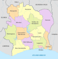
Dystrykty

Regiony (na szaro zaznaczono dystrykty wydzielone)
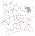
Departamenty (na szaro zaznaczono Park Narodowy Komoé niewchodzący w skład żadnego z departamentów)

Podprefektury (na szaro zaznaczono Park Narodowy Komoé oraz Abidżan nie wchodzące w skład żadnej podprefektury)

Gminy (zaznaczone zielonymi kropkami)
Podziały administracyjne od 1961
| Mapa | Lata obowiązywania | Jednostka pierwszego stopnia | Jednostka drugiego stopnia | Jednostka trzeciego stopnia | Uwagi |
|---|---|---|---|---|---|
.jpg) | 1961–1963 | 4 departamenty | – | – | 4 departamenty utworzone jako jednostki 1. stopnia. |
.jpg) | 1963–1969 | 6 departamentów | – | – | Dodano 2 departamenty. |
.jpg) | 1969–1974 | 24 departamenty | – | – | Wszystkie poprzednie departamenty zostały zlikwidowane. 24 nowe departamenty utworzono jako jednostki 1. stopnia. |
.jpg) | 1974–1980 | 26 departamentów | – | – | Dodano 2 departamenty. |
.jpg) | 1980–1988 | 34 departamenty | – | – | Dodano 8 departamentów. |
.jpg) | 1988–1995 | 49 departamentów | – | – | Dodano 15 departamentów. |
.jpg) | 1995–1997 | 50 departamentów | – | – | Dodano 1 departament. |
.jpg) | 1997–1998 | 16 regionów | 50 departamentów | – | Utworzono 16 regionów jako jednostki 1. stopnia. Departamenty zmieniono na jednostki 2. stopnia. |
.jpg) | 1998–2000 | 16 regionów | 58 departamentów | – | Dodano 8 departamentów. |
.jpg) | 2000-2005 | 19 regionów | 58 departamentów | – | Dodano 3 regiony. |
.jpg) | 2005–2008 | 19 regionów | 70 departamentów | – | Dodano 12 departamentów. |
.jpg) | 2008–2009 | 19 regionów | 81 departamentów | – | Dodano 11 departamentów. |
.jpg) | 2009–2011 | 19 regionów | 90 departamentów | – | Dodano 9 departamentów. |
.jpg) | 2011–2012 | 14 dystryktów | 30 regionów | 95 departamentów | Utworzono 14 dystryktów jako jednostki 1. stopnia. Zwiększono ilość regionów do 30 i zmieniono na jednostki 2. stopnia. Dodano 5 departamentów i zmieniono na jednostki 3. stopnia. Park Narodowy Komoé wydzielony spod jurysdykcji departamentów. |
.jpg) | 2012–2013 | 14 dystryktów | 31 regionów | 107 departamentów | Dodano 1 region i 12 departamentów. |
 | od 2013 | 14 dystryktów | 31 regionów | 108 departamentów | Dodano 1 departament. |
Przypisy
- ↑ a b Décentralisation : Le gouvernement créé 12 districts et 30 régions, Abidjan.net, 29 września 2011 [dostęp 2019-01-29] (fr.).
- ↑ Décret n° 2011-263 du 28 septembre 2011 portant organisation du territoire national en Districts et en Régions, Le Président de la République, 28 września 2011 [dostęp 2019-01-29] (fr.).
- ↑ Conseil des Ministres du mercredi 04 Juillet 2012 : De nouvelles entités administratives créées, Abidjan.net, 5 lipca 2012 [dostęp 2019-01-29] (fr.).
- ↑ Décret n° 2012-612 du 04 juillet 2012 portant création de la Région du Moronou, 4 lipca 2012 [dostęp 2019-01-29] [zarchiwizowane z adresu 2016-03-02] (fr.).
Linki zewnętrzne
- Oficjalna mapa administracyjna Wybrzeża Kości Słoniowej (Od czasu opublikowania tej mapy dokonano kilku zmian w podziale administracyjnym kraju: region Moronou został utworzony z Regionu N'Zi, utworzono 13 nowych departamentów i 12 podprefektur).
![]()
Media użyte na tej stronie

Autor: Good Olfactory, Licencja: CC BY-SA 4.0
Blank map of the departments of Côte d'Ivoire. Red lines indicate borders of the first-level districts. Bold black lines indicate borders of the second-level regions. The greyed out portion is an area of the country that is not governed by any department.
Autor: Good Olfactory, Licencja: CC BY-SA 4.0
Blank map of the the 70 departments of Côte d'Ivoire that existed between 2005 and 2008. Region (first-level division) boundaries in red. Department (second-level division) boundaries in black.
Autor: Good Olfactory, Licencja: CC BY-SA 4.0
Blank map of the the 58 departments of Côte d'Ivoire that existed between 1998 and 2000. Region (first-level division) boundaries in red. Department (second-level division) boundaries in black. The same departmental boundaries existed until 2005, but in 2000 the number of regions was increased.
.jpg)
Autor: Good Olfactory, Licencja: CC BY-SA 4.0
Blank map of the regions of Côte d'Ivoire. These regions are the regions instituted in 2011–12 as second-level administrative subdivisions. District borders are marked in red. The autonomous districts, which are not regions nor divided into regions, are in grey.
Autor: Good Olfactory, Licencja: CC BY-SA 4.0
Labelled map of the departments of Côte d'Ivoire (1961–63).
Autor: Good Olfactory, Licencja: CC BY-SA 4.0
Blank map of the the 34 departments of Côte d'Ivoire that existed between 1980 and 1988.

Autor: Good Olfactory, Licencja: CC BY-SA 4.0
Map of the sub-prefectures of Côte d'Ivoire. The dotted lines are the boundaries of the sub-prefectures and the green dot indicates the location of the settlement that is the seat of the sub-prefecture. District borders are in red; region borders are in bolded black; department boundaries are solid lines. Grey zones are areas of the country not governed by sub-prefectures (Abidjan city proper (south) and the portion of Comoé National Park in Zanzan District (north)).
Autor: Good Olfactory, Licencja: CC BY-SA 4.0
Blank map of the the 26 departments of Côte d'Ivoire that existed between 1974 and 1980.
Autor: Good Olfactory, Licencja: CC BY-SA 4.0
Blank map of the the 95 departments of Côte d'Ivoire that existed between 2011 and 2012. District (first-level division) boundaries in red. Region (second-level division) boundaries in bold black. Department (third-level division) boundaries in light black.
Autor: Good Olfactory, Licencja: CC BY-SA 4.0
Blank map of the the 50 departments of Côte d'Ivoire that existed between 1997 and 1998. Region (first-level division) boundaries in red. Department (second-level division) boundaries in black. The same departmental boundaries were established in 1995, but in 1997 regions were created.
Autor: Good Olfactory, Licencja: CC BY-SA 4.0
Blank map of the the 90 departments of Côte d'Ivoire that existed between 2009 and 2011. Region (first-level division) boundaries in red. Department (second-level division) boundaries in black.
Autor: Good Olfactory, Licencja: CC BY-SA 4.0
Blank map of the the 50 departments of Côte d'Ivoire that existed between 1995 and 1997. The same departmental boundaries existed until 1998, but in 1997, regions were created.
Autor: Good Olfactory, Licencja: CC BY-SA 4.0
Departments of Ivory Coast. Red lines indicate borders of districts. Bolded black lines indicate borders of regions.
Autor: Good Olfactory, Licencja: CC BY-SA 4.0
Blank map of the the 49 departments of Côte d'Ivoire that existed between 1988 and 1995.

Autor: Good Olfactory, Licencja: CC BY-SA 4.0
Map of the communes of Côte d'Ivoire. Green dots indicate the location of the settlement that is the seat of the commune. There are 197 communes in Côte d'Ivoire. Red lines indicate district boundaries and black lines indicate regional boundaries with districts.
Autor: Good Olfactory, Licencja: CC BY-SA 4.0
Blank map of the the 107 departments of Côte d'Ivoire that existed between 2012 and 2013. District (first-level division) boundaries in red. Region (second-level division) boundaries in bold black. Department (third-level division) boundaries in light black.


Autor: NordNordWest, Pikne (tłumaczenie), Licencja: CC BY-SA 3.0 de
Elevandiluuranniku ringkondade kaart
Autor: Good Olfactory, Licencja: CC BY-SA 4.0
Blank map of the the 81 departments of Côte d'Ivoire that existed between 2008 and 2009. Region (first-level division) boundaries in red. Department (second-level division) boundaries in black.
Autor: Good Olfactory, Licencja: CC BY-SA 4.0
Blank map of the the 58 departments of Côte d'Ivoire that existed between 2000 and 2005. Region (first-level division) boundaries in red. Department (second-level division) boundaries in black. The same departmental boundaries were established in 1998, but in 2000 the region boundaries changed.
Autor: Good Olfactory, Licencja: CC BY-SA 4.0
Labelled map of the departments of Côte d'Ivoire (1963–69).
Autor: Good Olfactory, Licencja: CC BY-SA 4.0
Blank map of the the 24 departments of Côte d'Ivoire that were established in 1969. These boundaries were consistent until 1974, when departments began to be divided.