Point Pleasant (Wirginia Zachodnia)
 | |
| Państwo | |
|---|---|
| Stan | |
| Populacja (2010) • liczba ludności • gęstość |
|
| Nr kierunkowy | 304 |
| Kod pocztowy | 25550 |
| Strona internetowa | |
| Portal | |
Point Pleasant – miasto w hrabstwie Mason w stanie Wirginia Zachodnia, leżące przy ujściu rzeki Kanawha do Ohio. Miejscowość jest położona na granicy stanów Ohio i Wirginia Zachodnia. W 2000 miało ponad 4600 ludności.
Miejscowość jest najbardziej znana z katastrofy mostu Silver Bridge w 1967 roku w której zginęło 46 osób. Z tym zdarzeniem związana jest miejska legenda, która mówi o człowieku-ćmie rzekomo widywanym kilka tygodni przed tym zdarzeniem. Stwór miał przepowiadać katastrofę. Na podstawie tego zdarzenia powstała książka oraz film Przepowiednia.
Linki zewnętrzne
- Strona miejscowości
- Biuro turystyki hrabstwa Mason
- Izba gospodarcza hrabstwa Mason
- The Point Pleasant Register
Media użyte na tej stronie
Autor: Uwe Dedering, Licencja: CC BY-SA 3.0
Location map of the USA (without Hawaii and Alaska).
EquiDistantConicProjection:
Central parallel:
* N: 37.0° N
Central meridian:
* E: 96.0° W
Standard parallels:
* 1: 32.0° N
* 2: 42.0° N
Made with Natural Earth. Free vector and raster map data @ naturalearthdata.com.
Formulas for x and y:
x = 50.0 + 124.03149777329222 * ((1.9694462586094064-({{{2}}}* pi / 180))
      * sin(0.6010514667026994 * ({{{3}}} + 96) * pi / 180))
y = 50.0 + 1.6155950752393982 * 124.03149777329222 * 0.02613325650382181
      - 1.6155950752393982  * 124.03149777329222 *
     (1.3236744353715044  - (1.9694462586094064-({{{2}}}* pi / 180))
      * cos(0.6010514667026994 * ({{{3}}} + 96) * pi / 180))
The flag of Navassa Island is simply the United States flag. It does not have a "local" flag or "unofficial" flag; it is an uninhabited island. The version with a profile view was based on Flags of the World and as a fictional design has no status warranting a place on any Wiki. It was made up by a random person with no connection to the island, it has never flown on the island, and it has never received any sort of recognition or validation by any authority. The person quoted on that page has no authority to bestow a flag, "unofficial" or otherwise, on the island.
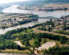
The confluence of the Kanawha and Ohio Rivers. The Kanawha River flows in from the left of the picture and joins the Ohio, meandering off in the distance. The town of Point Pleasant, West Virginia is in the foreground on the right. Henderson, West Virginia is on the left. The Ohio River forms the boundary between West Virginia and Ohio. The town of Gallipolis, Ohio lies in the far distance across the Ohio River. The view is to the west-southwest down the river.
Autor: Alexrk2, Licencja: CC BY 3.0
Location map of West Virginia, USA
Equirectangular projection, N/S stretching 130.0 %. Geographic limits of the map:
- N: 40.8° N
- S: 37.0° N
- W: 82.8° W
- E: 77.5° W


