Polarna czapa lodowa

Polarna czapa lodowa − obszar okołobiegunowy planety (lub księżyca planety) pokryty lodem. Termin ten obejmuje zarówno obszary pokryte lądolodami, jak też lód morski. Na Ziemi występują one w Arktyce i Antarktyce.
Polarne czapy lodowe może tworzyć zarówno lód wodny, jak też inne substancje występujące w stanie stałym w obszarze podbiegunowym danego ciała niebieskiego; na Marsie, oprócz wody, czapy polarne tworzy zestalony dwutlenek węgla[1].
Ziemskie czapy polarne
Na Ziemi czapy lodowe pokrywają kontynent Antarktydy i okoliczne morza (półkula południowa) oraz Ocean Arktyczny wraz z wyspą Grenlandią (północna). W ujęciu rocznym ich zasięg zmienia się na skutek sezonowych zmian pokrywy lodu morskiego. W ujęciu wieloletnim trend zmian jest różny dla obu półkul. W związku z ociepleniem klimatu w Arktyce maleje zarówno zasięg lodu morskiego, jak i lądowego. W Antarktyce zaś spada powierzchnia zajmowana przez lód lodowcowy, powiększa się natomiast zasięg sezonowego lodu morskiego. W historii geologicznej zasięg czap polarnych ulegał znacznym wahaniom, w okresach zlodowaceń obejmowały one znaczną część obu półkul[2][3], ale bywały też okresy gdy Ziemia nie posiadała czap polarnych, a w regionach podbiegunowych panował klimat umiarkowany[4][5]. Lądolody, bardzo rozległe w plejstocenie, ograniczają się obecnie do Antarktydy na półkuli południowej i lądolodu grenlandzkiego na półkuli północnej. Przy dzisiejszym układzie kontynentów nawet całkowite stopienie czap lodowych nie spowodowałoby znacznego zmniejszenia powierzchni lądów na Ziemi, ale dotknęłoby wiele gęsto zamieszkanych, nizinnych obszarów nadmorskich[6].
Marsjańskie czapy polarne

Mars również posiada czapy polarne na obu biegunach, przy czym północna ma większy zasięg. Są one złożone z zamarzniętej wody z dodatkiem dwutlenku węgla, czyli suchego lodu. Ze względu na nachylenie osi obrotu Marsa podobne do ziemskiego, na obu planetach występują podobne pory roku. W czasie marsjańskiej zimy w północnej okolicy podbiegunowej powstaje warstwa zamarzniętego dwutlenku węgla o miąższości 1 metra, która sublimuje całkowicie w lecie; zimowa warstwa suchego lodu na południu jest osiem razy grubsza i nie znika całkowicie nawet w lecie[1]. Szczeliny widoczne w północnej czapie lodowej, w tym wielki kanion Chasma Boreale, ukazują liczne warstwy lodu i pyłu naniesionego przez burze piaskowe.
Czapy polarne na księżycach Układu Słonecznego
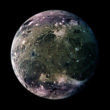
Czapy lodowe, złożone głównie z lodu wodnego, posiada krążący wokół Jowisza Ganimedes, największy księżyc w Układzie Słonecznym. Ich istnienie (i brak czapy polarnej na podobnej wielkości księżycu Kallisto) może być związane z dawną aktywnością geologiczną Ganimedesa[7], lub też z uderzeniami cząstek plazmy poruszającej się w polu magnetycznym Jowisza[8].
Także na Trytonie, księżycu Neptuna, sonda Voyager 2 zaobserwowała rozległą południową czapę polarną. Tworzy ją zestalony azot i metan[9]. Czapa lodowa występuje prawdopodobnie również na Plutonie[10].
Zobacz też
Przypisy
- ↑ a b Mars Polar Regions. Windows to the Universe, 2008-07-07. [dostęp 2011-02-23].
- ↑ Paleomap Project: Last Ice Age
- ↑ Paleomap Project: Late Carboniferous Climate
- ↑ Paleomap Project: Early Eocene Climate
- ↑ Paleomap Project: Late Triassic Climate
- ↑ "What If All the Ice Melts?" Myths and Realities
- ↑ Edward J. Shaya, Carl B. Pilcher. Polar cap formation on Ganymede. „Icarus”. 58 (1), s. 74-80, kwiecień 1984. DOI: 10.1016/0019-1035(84)90098-8.
- ↑ R.E. Johnson. Polar ‘‘Caps’’ on Ganymede and Io Revisited. „Icarus”. 127, s. 469-471, 1997. [dostęp 2011-02-22].
- ↑ The Poles of Triton. Windows to the Universe, 2009-04-21. [dostęp 2011-02-22].
- ↑ New Horizons Sees More Detail as It Draws Closer to Pluto. [w:] New Horizons [on-line]. Uniwersytet Johnsa Hopkinsa, Applied Physics Laboratory, 2015-05-27. [dostęp 2015-06-07].
Media użyte na tej stronie
"The Blue Marble" is a famous photograph of the Earth taken on December 7, 1972, by the crew of the Apollo 17 spacecraft en route to the Moon at a distance of about 29,000 kilometres (18,000 mi). It shows Africa, Antarctica, and the Arabian Peninsula.
In this global view of Ganymede's trailing side, the colors are enhanced to emphasize color differences. The enhancement reveals frosty polar caps in addition to the two predominant terrains on Ganymede, bright, grooved terrain and older, dark furrowed areas. Many craters with diameters up to several dozen kilometers are visible. The violet hues at the poles may be the result of small particles of frost which would scatter more light at shorter wavelengths (the violet end of the spectrum). Ganymede's magnetic field, which was detected by the magnetometer on NASA's Galileo spacecraft in 1996, may be partly responsible for the appearance of the polar terrain. Compared to Earth's polar caps, Ganymede's polar terrain is relatively vast. The frost on Ganymede reaches latitudes as low as 40 degrees on average and 25 degrees at some locations. For comparison with Earth, Miami, Florida lies at 26 degrees north latitude, and Berlin, Germany is located at 52 degrees north. North is to the top of the picture. The composite, which combines images taken with green, violet, and 1 micrometer filters, is centered at 306 degrees west longitude. The resolution is 9 kilometers (6 miles) per picture element. The images were taken on 29 March 1998 at a range of 918000 kilometers (570,000 miles) by the Solid State Imaging (SSI) system on NASA's Galileo spacecraft.
Taking advantage of Mars's closest approach to Earth in eight years, astronomers using NASA's Hubble Space Telescope have taken the space-based observatory's sharpest views yet of the Red Planet.
The telescope's Wide Field and Planetary Camera 2 snapped these images between April 27 and May 6, when Mars was 54 million miles (87 million kilometers) from Earth. From this distance the telescope could see Martian features as small as 12 miles (19 kilometers) wide.
The telescope obtained four images, which, together, show the entire planet. Each view depicts the planet as it completes one quarter of its daily rotation. In these views the north polar cap is tilted toward the Earth and is visible prominently at the top of each picture. The images were taken in the middle of the Martian northern summer, when the polar cap had shrunk to its smallest size. During this season the Sun shines continuously on the polar cap. Previous telescopic and spacecraft observations have shown that this summertime "residual" polar cap is composed of water ice, just like Earth's polar caps.
These Hubble telescope snapshots reveal that substantial changes in the bright and dark markings on Mars have occurred in the 20 years since the NASA Viking spacecraft missions first mapped the planet. The Martian surface is dynamic and ever changing. Some regions that were dark 20 years ago are now bright red; some areas that were bright red are now dark. Winds move sand and dust from region to region, often in spectacular dust storms. Over long timescales many of the larger bright and dark markings remain stable, but smaller details come and go as they are covered and then uncovered by sand and dust.
This image is centered near the location of the Pathfinder landing site. Dark sand dunes that surround the polar cap merge into a large, dark region called Acidalia. This area, as shown by images from the Hubble telescope and other spacecraft, is composed of dark, sand-sized grains of pulverized volcanic rock.
Below and to the left of Acidalia are the massive Martian canyon systems of Valles Marineris, some of which form long linear markings that were once thought by some to be canals. Early morning clouds can be seen along the left limb of the planet, and a large cyclonic storm composed of water ice is churning near the polar cap.


