Poligon Nevada
| ||
| Państwo | ||
| Stan | ||
| Rodzaj bazy | poligon wojskowy | |
| Typ bazy | poligon atomowy | |
| Historia | ||
| Używana od | 11 stycznia 1951 | |
| Użytkownicy | ||
| Departament Energii Stanów Zjednoczonych, Siły Zbrojne Stanów Zjednoczonych | ||
Położenie na mapie Nevady  | ||
Położenie na mapie Stanów Zjednoczonych  | ||
_002.jpg)

Poligon Nevada (ang. Nevada Test Site) – poligon atomowy leżący około 105 km na północny zachód od Las Vegas w hrabstwie Nye na obszarze Strefy Sił Powietrznych Nellis. Zarządzany przez Departament Energii Stanów Zjednoczonych.
Powstał 11 stycznia 1951 roku w celu testowania broni jądrowej. W przybliżeniu, 3500 km² pustyni i górzystego terenu. Badania rozpoczęły się od zrzucenia bomby o wagomiarze jednej kilotony na Frenchman Flat 27 stycznia tego samego roku. Wykonano tu wiele znanych rejestracji i zdjęć wybuchów nuklearnych. Na potrzeby wojska wybudowano tu:
- 1100 budynków,
- 400 mil (643 km) dróg asfaltowych,
- 300 mil (482 km) dróg gruntowych,
- 10 lądowisk dla helikopterów,
- 2 pasy startowe.
W latach 1951–1992 przeprowadzono 925 eksplozji jądrowych z czego 825 podziemnych (sejsmografy wskazują, że mogło być ich więcej). Jest najważniejszym ze wszystkich amerykańskich poligonów. Tylko 129 testów przeprowadzono w innych miejscach (m.in. Pacific Proving Grounds na Wyspach Marshalla).
Na południu znajduje się miasteczko Mercury, w którym są laboratoria Los Alamos, Lawrence Livermore i Sandia National Laboratories. Yucca Mountain jest wygodnym miejscem do przechowywaniach odpadów promieniotwórczych. Od roku 2004 oferowane są wycieczki osób cywilnych po bezpiecznych miejscach. Zakazany jest handel i zbieranie pamiątek.
2 czerwca 2006 roku postanowiono rozpocząć testowanie broni konwencjonalnej (Divine Strake). Mimo poparcia George’a W. Busha, Kongres Stanów Zjednoczonych jest niechętny finansowaniu prób atomowych, do czego przychylają się także rządy stanowe Nevady i Utah. Decyzją Kongresu, operacja została bezterminowo zawieszona.
Galeria

Operacja Doorstep (1953) – manekiny przeznaczone do testów (przed odpaleniem ładunku).
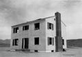
Operacja Doorstep (1953), lekko uszkodzony drewniany dom po eksplozji.
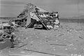
Operacja Doorstep (1953), ruiny drewnianego domu po eksplozji.
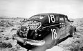
Operacja Doorstep (1953), próbny samochód przed eksplozją.

Operacja Doorstep (1953), manekiny w przybudówce piwnicznej przed eksplozją.


Zobacz też
- National Atomic Testing Museum
Linki zewnętrzne
| ||||||||||||||
Media użyte na tej stronie
Autor: Uwe Dedering, Licencja: CC BY-SA 3.0
Location map of the USA (without Hawaii and Alaska).
EquiDistantConicProjection:
Central parallel:
* N: 37.0° N
Central meridian:
* E: 96.0° W
Standard parallels:
* 1: 32.0° N
* 2: 42.0° N
Made with Natural Earth. Free vector and raster map data @ naturalearthdata.com.
Formulas for x and y:
x = 50.0 + 124.03149777329222 * ((1.9694462586094064-({{{2}}}* pi / 180))
      * sin(0.6010514667026994 * ({{{3}}} + 96) * pi / 180))
y = 50.0 + 1.6155950752393982 * 124.03149777329222 * 0.02613325650382181
      - 1.6155950752393982  * 124.03149777329222 *
     (1.3236744353715044  - (1.9694462586094064-({{{2}}}* pi / 180))
      * cos(0.6010514667026994 * ({{{3}}} + 96) * pi / 180))

The flag of Navassa Island is simply the United States flag. It does not have a "local" flag or "unofficial" flag; it is an uninhabited island. The version with a profile view was based on Flags of the World and as a fictional design has no status warranting a place on any Wiki. It was made up by a random person with no connection to the island, it has never flown on the island, and it has never received any sort of recognition or validation by any authority. The person quoted on that page has no authority to bestow a flag, "unofficial" or otherwise, on the island.

Crater from the 1962 "Sedan" nuclear test as part of Operation Plowshare. The 104 kiloton blast displaced 12 million tons of earth and created a crater 320 feet deep and 1,280 feet wide. (Look to the size of the roads in the bottom-right of the picture, and the observation deck at the lower-right edge of the crater, for a sense of scale)
Operation Buster-Jangle - Dog test — with troops participating in exercise Desert Rock I.
- It was the first U.S. nuclear field exercise conducted on land; troops shown are a mere 6 miles from the blast.
- At the Category:Nevada Test Site, 1 November 1951.
Autor: Finlay McWalter, Licencja: CC-BY-SA-3.0
Map of federal lands in southern Nevada, including:
- Nellis Air Force Base
- Area 51
- Tonopah Test Range
- Yucca Mountain
- Mercury
- Nevada Test Site
- Nellis Air Force Range
- Desert National Wildlife Range
- Method of production
- a topographic map was rendered using Demis' mapserver. This combines public domain datasets and renders an image. Demis allows unlimited use of this: [1] says With this statement DEMIS BV grants you permission to freely copy the PNG images returned by our server and use them for your own purposes, including web pages.
- A second version was referenced with the same geometry but with all the available layers turned on. This was used as a guideline for the positions of roads and cities, although the second rendered map is not used in the final rendered image.
- The map was imported in to Inkscape where annotations were drawn in several layers over the bitmap.
- Roads were manually traced from the road lines in the detail map, and cities located from that reference.
- Maps (listed in references) used for reference when placing features (most features are somewhat schematic, with only moderate attention to details of precise size and location).
- Errors
0. Numerous federal land areas are missing
1. Names are outdated
2. The scale is not consistent within the image
Flag of the State of Nevada. The flag is described in Nevada Revised Statutes Chapter 235, Sec. 20 as follows: The body of the flag must be of solid cobalt blue. On the field in the upper left quarter thereof must be two sprays of Sagebrush with the stems crossed at the bottom to form a half wreath. Within the sprays must be a five-pointed silver star with one point up. The word “Nevada” must also be inscribed below the star and above the sprays, in a semicircular pattern with the letters spaced apart in equal increments, in the same style of letters as the words “Battle Born.” Above the wreath, and touching the tips thereof, must be a scroll bearing the words “Battle Born.” The scroll and the word “Nevada” must be golden-yellow. The lettering on the scroll must be black-colored sans serif gothic capital letters.