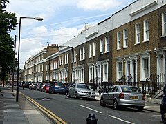
Poplar (Londyn)
(c) ceridwen, CC BY-SA 2.0 | |
| Państwo | |
|---|---|
| Kraj | |
| Region | |
| Dystrykt | |
| Nr kierunkowy | 020 |
| Kod pocztowy | E14 |
Położenie na mapie Wielkiego Londynu Contains Ordnance Survey data © Crown copyright and database right, CC BY-SA 3.0 | |
Położenie na mapie Wielkiej Brytanii (c) Karte: NordNordWest, Lizenz: Creative Commons by-sa-3.0 de | |
| 51°30′24″N 0°01′04″W/51,506600 -0,017800 | |
| Portal | |
Poplar – dzielnica Londynu (w latach 1817-1907 civil parish)[1], leżące w gminie London Borough of Tower Hamlets[2].
Przypisy
Media użyte na tej stronie
Contains Ordnance Survey data © Crown copyright and database right, CC BY-SA 3.0
Map of Greater London, UK with the following information shown:
- Administrative borders
- Coastline, lakes and rivers
- Roads and railways
- Urban areas
The data includes both primary routes and railway lines.
Equirectangular map projection on WGS 84 datum, with N/S stretched 160%
Geographic limits:
- West: 0.57W
- East: 0.37E
- North: 51.72N
- South: 51.25N
(c) Karte: NordNordWest, Lizenz: Creative Commons by-sa-3.0 de
Location map of the United Kingdom
Flag of England. Saint George's cross (a red cross on a white background), used as the Flag of England, the Italian city of Genoa and various other places.
(c) ceridwen, CC BY-SA 2.0
Woodstock Terrace, Poplar Mid-C19 terrace facing Poplar Park and running between Poplar High Street and East India Dock Road. The houses were built by a number of different developers but covenants "prohibited the lessees and their tenants from practising specified noxious trades, including the boiling of horseflesh, tallow melting and soapmaking, and from using forges, anvils or steam engines on the premises. Woodstock Terrace attracted generally middle-class occupants and it was thought to be one of the most respectable streets in Poplar. In 1881 the occupants included two clergymen, two schoolmistresses, a schoolmaster, a wine merchant, three clerks and two master mariners." From: 'Between Poplar High Street and East India Dock Road: Woodstock Terrace and the Clippingdale, Griffiths and St Matthias estates', Survey of London: volumes 43 and 44: Poplar, Blackwall and Isle of Dogs (1994), pp. 173-176. URL: http://www.british-history.ac.uk/report.aspx?compid=46483. Date accessed: 01 July 2008.


