Porirua
 | |
| Państwo | |
|---|---|
| Region | |
| Burmistrz | Jenny Brash |
| Powierzchnia | 182.39 km² |
| Populacja • liczba ludności |
|
| Kod pocztowy | 5010 – 5381 |
| Strona internetowa | |
| Portal | |
Porirua – miasto w Nowej Zelandii; na Wyspie Północnej; w aglomeracji Wellington; ok. 49000 mieszkańców (2009)[1]. Przemysł spożywczy, drzewny.
Prawa miejskie uzyskało 2 października 1965 roku[2].
Miasta partnerskie
Przypisy
- ↑ a b http://world-gazetteer.com/wg.php?x=&men=gcis&lng=en&des=wg&srt=npan&col=abcdefghinoq&msz=1500&geo=-165
- ↑ NZ Elective Structures Since Colonisation (ang.). pcc.govt.nz. [dostęp 2015-09-17]. [zarchiwizowane z tego adresu (2015-06-13)].
- ↑ Wellington Region Sister Cities. [dostęp 2009-05-09]. [zarchiwizowane z tego adresu (23 sierpnia 2007)].
Media użyte na tej stronie
Autor: NordNordWest, Licencja: CC BY-SA 3.0
Location map of New Zealand
Flag of New Zealand. Specification: http://www.mch.govt.nz/nzflag/description.html , quoting New Zealand Gazette, 27 June 1902.
Autor: Derrick Coetzee (User:Dcoetzee), Licencja: CC0
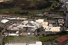
Viewed from west, with considerable visible detail at 100%. In upper right with the crowded parking lot is Porirua Station. North City Shopping Centre is on right (tan colored building with Kmart and Farmer's logo). State Highway 1 (SH 1N) and railway are at top. Green-walled building on left is a Countdown supermarket.


