Port lotniczy Chengdu-Shuangliu
| |||
 | |||
| Państwo | |||
| Miejscowość | Chengdu | ||
| Typ | cywilne | ||
| Kod IATA | CTU | ||
| Kod ICAO | ZUUU | ||
| Wysokość | 495 m n.p.m. | ||
| Statystyki ruchu (2018[1]) | |||
| Liczba pasażerów | 52 950 529 | ||
| Cargo | 665,128,4 t | ||
| Liczba operacji | 352 124 | ||
| Drogi startowe | |||
|---|---|---|---|
| |||
Położenie na mapie Chin  | |||
Port lotniczy Chengdu-Shuangliu (IATA: CTU, ICAO: ZUUU) – międzynarodowy port lotniczy położony 16 km na południowy zachód od centrum Chengdu, w prowincji Syczuan, w Chinach.
Przypisy

CTU T1 International
Terminal 2 of Chengdu Shuangliu Int'l Airport

Terminal 2 concourse of Chengdu Shuangliu Int'l Airport
Media użyte na tej stronie


Legenda lotnisko.svg
Symbol lotniska do legendy mapy
Symbol lotniska do legendy mapy

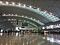
Terminal 2 concourse of Chengdu Shuangliu Int'l Airport.jpg
Autor: Wwklion, Licencja: CC BY-SA 4.0
Terminal 2 concourse of Chengdu Shuangliu Int'l Airport
Autor: Wwklion, Licencja: CC BY-SA 4.0
Terminal 2 concourse of Chengdu Shuangliu Int'l Airport

Terminal 2 of Chengdu Shuangliu Int'l Airport.jpg
Autor: Wwklion, Licencja: CC BY-SA 4.0
Terminal 2 of Chengdu Shuangliu Int'l Airport]]
Autor: Wwklion, Licencja: CC BY-SA 4.0
Terminal 2 of Chengdu Shuangliu Int'l Airport]]

China edcp location map.svg
Autor: Uwe Dedering, Licencja: CC BY-SA 3.0
Location map of China.
Autor: Uwe Dedering, Licencja: CC BY-SA 3.0
Location map of China.
EquiDistantConicProjection : Central parallel :
- N: 36.0° N
Central meridian :
- E: 104.0° E
Standard parallels:
- 1: 30.0° N
- 2: 42.0° N
Latitudes on the central meridian :
- top: 57.0° E
- center: 37° 29′ N
- bottom: 17.96° N
Terminal 2 of CTU.jpg
Autor: AlexHe34, Licencja: CC BY-SA 3.0
Check-in Counters in Terminal 2, Chengdu Shuangliu International Airport.
Autor: AlexHe34, Licencja: CC BY-SA 3.0
Check-in Counters in Terminal 2, Chengdu Shuangliu International Airport.