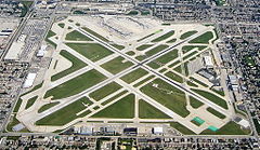
Port lotniczy Chicago-Midway
 | |||||||||||
| Państwo | |||||||||||
|---|---|---|---|---|---|---|---|---|---|---|---|
| Miejscowość | |||||||||||
| Typ | cywilne | ||||||||||
| Właściciel | Chicago Airport System | ||||||||||
| Kod IATA | MDW | ||||||||||
| Kod ICAO | KMDW | ||||||||||
| Wysokość | 189 m n.p.m. | ||||||||||
| Statystyki ruchu (2010[1]) | |||||||||||
| Liczba pasażerów | 17 676 413 | ||||||||||
| Cargo | 28 227 t | ||||||||||
| Liczba operacji | 245 533 | ||||||||||
| Drogi startowe | |||||||||||
| |||||||||||
Port lotniczy Chicago-Midway – międzynarodowy port lotniczy położony na południowy zachód od centrum Chicago, w stanie Illinois. Jest drugim portem lotniczym Chicago po Porcie lotniczym Chicago-O’Hare.
Linie lotnicze i połączenia
Hall A
- AirTran Airways (Atlanta, Boston [sezonowo], Fort Myers [sezonowo], Miami, Orlando, Sarasota/Bradenton)
- Delta Air Lines
- Delta Connection obsługiwane przez Shuttle America (Nowy Jork-LaGuardia)
- Frontier Airlines (Denver)
- obsługiwane przez Frontier Airlines (Cancún) [czartery weekendowe]
- Northwest Airlines (Detroit, Minneapolis/St. Paul)
- Northwest Airlink obsługiwane przez Compass Airlines (Detroit, Minneapolis/St. Paul)
- Northwest Airlink obsługiwane przez Mesaba Airlines (Detroit)
- Southwest Airlines (Patrz Hall B)
Hall B
- Southwest Airlines (Albany, Albuquerque, Austin, Baltimore/Waszyngton, Birmingham (AL), Buffalo, Cleveland, Columbus (OH), Denver, Detroit, Fort Lauderdale, Fort Myers, Hartford/Springfield, Houston-Hobby, Indianapolis, Jackson, Kansas City, Las Vegas, Little Rock, Long Island/Islip, Los Angeles, Louisville, Manchester (NH), Nashville, Nowy Orlean, Norfolk, Oakland, Omaha, Orlando, Filadelfia, Phoenix, Pittsburgh, Portland (OR), Providence, Raleigh/Durham, Reno/Tahoe, Sacramento, Salt Lake City, San Antonio, San Diego, San Francisco, San Jose (CA), Seattle/Tacoma, St. Louis, Tampa, Tucson, Waszyngton-Dulles)
Hall C
- Delta Air Lines
- Delta Connection obsługiwane przez Comair (Atlanta)
- Delta Connection obsługiwane przez Shuttle America (Atlanta)
Przypisy
Media użyte na tej stronie
Autor: Uwe Dedering, Licencja: CC BY-SA 3.0
Location map of the USA (without Hawaii and Alaska).
EquiDistantConicProjection:
Central parallel:
* N: 37.0° N
Central meridian:
* E: 96.0° W
Standard parallels:
* 1: 32.0° N
* 2: 42.0° N
Made with Natural Earth. Free vector and raster map data @ naturalearthdata.com.
Formulas for x and y:
x = 50.0 + 124.03149777329222 * ((1.9694462586094064-({{{2}}}* pi / 180))
      * sin(0.6010514667026994 * ({{{3}}} + 96) * pi / 180))
y = 50.0 + 1.6155950752393982 * 124.03149777329222 * 0.02613325650382181
      - 1.6155950752393982  * 124.03149777329222 *
     (1.3236744353715044  - (1.9694462586094064-({{{2}}}* pi / 180))
      * cos(0.6010514667026994 * ({{{3}}} + 96) * pi / 180))
Autor: Alexrk2, Licencja: CC BY 3.0
Ta mapa została stworzona za pomocą GeoTools.
The flag of Navassa Island is simply the United States flag. It does not have a "local" flag or "unofficial" flag; it is an uninhabited island. The version with a profile view was based on Flags of the World and as a fictional design has no status warranting a place on any Wiki. It was made up by a random person with no connection to the island, it has never flown on the island, and it has never received any sort of recognition or validation by any authority. The person quoted on that page has no authority to bestow a flag, "unofficial" or otherwise, on the island.
Symbol lotniska do legendy mapy
Autor: Oryginalnym przesyłającym był Sox23 z angielskiej Wikipedii, Licencja: CC-BY-SA-3.0
An Aerial view facing east of Chicago Midway International Airport, a.k.a. the world's "Busiest Square Mile."
Photo taken and used with permission by: Chris Bungo
This photo can be found at: http://www.airliners.net/open.file/1265806/L/Autor: Dudemanfellabra, Licencja:
A map of Chicago, IL, and the surrounding area


