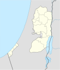
Port lotniczy Jasir Arafat
 | |||
| Państwo | / | ||
|---|---|---|---|
| Miejscowość | Rafah, Strefa Gazy | ||
| Typ | cywilne | ||
| Kod IATA | GZA | ||
| Kod ICAO | LVGZ | ||
| Wysokość | 98 m n.p.m. | ||
| Drogi startowe | |||
| |||
Port lotniczy Jasir Arafat (ang. Yasser Arafat International Airport, kod IATA: GZA, kod ICAO: LVGZ) – dawny międzynarodowy port lotniczy w Rafah, w Strefie Gazy (Autonomia Palestyńska). Działał w latach 1998–2001, aż został zniszczony przez Siły Obronne Izraela.
Linki zewnętrzne
Media użyte na tej stronie
Flag of Israel. Shows a Magen David (“Shield of David”) between two stripes. The Shield of David is a traditional Jewish symbol. The stripes symbolize a Jewish prayer shawl (tallit).
Symbol lotniska do legendy mapy
Autor: NordNordWest, Licencja: CC BY-SA 3.0
Location map of the Palestinian territories (West Bank and Gaza Strip)


