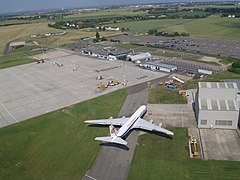
Port lotniczy Kent International
| Ten artykuł wymaga modyfikacji na podstawie najświeższych informacji. |
(c) James Stewart / jamesstewart.com, CC BY 2.0 | |||
| Państwo | |||
|---|---|---|---|
| Miejscowość | |||
| Typ | cywilne | ||
| Właściciel | Infratil Airports Europe | ||
| Kod IATA | MSE | ||
| Kod ICAO | EGMH | ||
| Strefa czasowa | UTC 0 | ||
| Wysokość | 54 m n.p.m. | ||
| Statystyki ruchu (2007) | |||
| Liczba pasażerów | 16 180 | ||
| Drogi startowe | |||
| |||
Położenie na mapie Kentu Contains Ordnance Survey data © Crown copyright and database right, CC BY-SA 3.0 | |||
Położenie na mapie Wielkiej Brytanii (c) Karte: NordNordWest, Lizenz: Creative Commons by-sa-3.0 de | |||
| Strona internetowa | |||
Międzynarodowy port lotniczy Kent (ang.: Kent International Airport, kod IATA: MSE, kod ICAO: EGMH) – międzynarodowy port lotniczy w Wielkiej Brytanii oddalone 20 km na północny wschód od miasta Canterbury w hrabstwie Kent. Lotnisko kiedyś było znane jako była baza militarna RAF Manston (baza militarna Royal Air Force) lub też znany jako London Manston Airport[1].
Port lotniczy Kent posiada licencje CAA Ordinary Licence (numer P880) który umożliwia publiczny transport pasażerów oraz dla zmiany instrukcji procedur lotniska (jak podane przez właściciela, w tym przypadku Infratil Airports Europe)[2].
Przypisy
- ↑ London Manston Airport pokazany na mapie Ordnance Survey z 2005 roku
- ↑ Civil Aviation Authority Aerodrome Ordinary Licences CAA (ang.). [dostęp 2009-11-09].
Linki zewnętrzne
- Oficjalna strona lotniska Kent International-Manston. [dostęp 2009-11-09].
Media użyte na tej stronie
An outdated clock with a serious icon
Symbol lotniska do legendy mapy
(c) James Stewart / jamesstewart.com, CC BY 2.0
African International Airways Douglas DC-8 at Manston Airport
(c) Karte: NordNordWest, Lizenz: Creative Commons by-sa-3.0 de
Location map of the United Kingdom
Contains Ordnance Survey data © Crown copyright and database right, CC BY-SA 3.0
Map of Kent, UK with the following information shown:
- Administrative borders
- Coastline, lakes and rivers
- Roads and railways
- Urban areas
Equirectangular map projection on WGS 84 datum, with N/S stretched 160%
Geographic limits:
- West: 0.01E
- East: 1.47E
- North: 51.52N
- South: 50.88N


