Port lotniczy Londyn-Biggin Hill
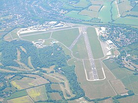
(c) Philip Talmage, CC BY-SA 2.0 | |||||
| Państwo | |||||
|---|---|---|---|---|---|
| Miejscowość | Bromley, Londyn | ||||
| Kod IATA | BQH | ||||
| Kod ICAO | EGKB | ||||
| Strefa czasowa | UTC 0 | ||||
| Wysokość | 183 m n.p.m. | ||||
| Drogi startowe | |||||
| |||||
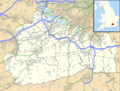
Położenie na mapie Surrey Contains Ordnance Survey data © Crown copyright and database right, CC BY-SA 3.0 | |||||
Położenie na mapie Wielkiej Brytanii (c) Karte: NordNordWest, Lizenz: Creative Commons by-sa-3.0 de | |||||
| Strona internetowa | |||||
Port lotniczy Londyn-Biggin Hill (ang.: London Biggin Hill Airport, kod IATA: BQH, kod ICAO: EGKB) – port lotniczy zlokalizowany w dzielnicy Londynu – Bromley (Wielka Brytania, Anglia)
Linki zewnętrzne
Media użyte na tej stronie
Contains Ordnance Survey data © Crown copyright and database right, CC BY-SA 3.0
Map of Surrey, UK with the following information shown:
- Administrative borders
- Coastline, lakes and rivers
- Roads and railways
- Urban areas
Equirectangular map projection on WGS 84 datum, with N/S stretched 160%
Geographic limits:
- West: 0.87W
- East: 0.08E
- North: 51.50N
- South: 51.05N
(c) Karte: NordNordWest, Lizenz: Creative Commons by-sa-3.0 de
Location map of the United Kingdom
Symbol lotniska do legendy mapy
Autor: Foma, Licencja: CC BY-SA 4.0
Aerial view of the London Biggin Hill Airport
(c) Philip Talmage, CC BY-SA 2.0
London Biggin Hill Airport passenger terminal. For more information see the Wikipedia article London Biggin Hill Airport.


