Port lotniczy Newcastle International
(c) Derek Harper, CC BY-SA 2.0 | |||
| Państwo | |||
|---|---|---|---|
| Kraj | |||
| Miejscowość | |||
| Typ | cywilne | ||
| Właściciel | miejscowe władze (7 rad, 51%) i Copenhagen Airports A/S (49%) | ||
| Kod IATA | NCL | ||
| Kod ICAO | EGNT | ||
| Wysokość | 81 m n.p.m. | ||
| Statystyki ruchu (2016[1]) | |||
| Liczba pasażerów | 4 800 000 | ||
| Liczba operacji | 55 000 | ||
| Drogi startowe | |||
| |||
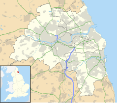
Położenie na mapie Tyne and Wear Contains Ordnance Survey data © Crown copyright and database right, CC BY-SA 3.0 | |||
Położenie na mapie Wielkiej Brytanii (c) Karte: NordNordWest, Lizenz: Creative Commons by-sa-3.0 de | |||
| Strona internetowa | |||
Port lotniczy Newcastle International (ang.: Newcastle International Airport, kod IATA: NCL, kod ICAO: EGNT) – międzynarodowe lotnisko położone 11 km na północ od centrum Newcastle upon Tyne w Anglii, 9. co do ilości przewiezionych pasażerów w kraju: 5 431 976 (2006).
Linie lotnicze i połączenia
| Linia lotnicza | Kierunek |
|---|---|
| Aer Lingus Regional | |
| Air France | |
| BMI Regional (do 16 lutego 2019) | |
| British Airways | |
| BH Air | Sezonowo: |
| EasyJet | Sezonowo: |
| Emirates | |
| Eurowings | |
| Flybe | Sezonowo: |
| Freebird Airlines | Sezonowe czartery: |
| Jet2.com | Sezonowo: |
| KLM | |
| Ryanair | Sezonowo: |
| Thomas Cook Airlines | Sezonowo: |
| TUI Airways |
Sezonowo:
Sezonowe czartery: |
Cargo
| Linia lotnicza | Kierunek |
|---|---|
| FedEx Express |
Przypisy
- ↑ Datasets | UK Civil Aviation Authority, www.caa.co.uk [dostęp 2017-11-26] (ang.).
- ↑ Cheap flights from Sofia Airport | Book with Flybe today!, www.flybe.com [dostęp 2018-03-25] (ang.).
- ↑ Flight Timetables | Jet2.com, www.jet2.com [dostęp 2018-03-25].
- ↑ Thomas Cook UK expands Hurghada routes in W17 :: Routesonline, www.routesonline.com [dostęp 2018-03-25] (ang.).
- ↑ Timetable - Thomas Cook Airlines, www.thomascookairlines.com [dostęp 2018-03-25] (ang.).
Media użyte na tej stronie
(c) Karte: NordNordWest, Lizenz: Creative Commons by-sa-3.0 de
Location map of the United Kingdom
Flag of England. Saint George's cross (a red cross on a white background), used as the Flag of England, the Italian city of Genoa and various other places.
Icon representing an increase, consisting of a green-colored, up-pointing triangle.
Icon representing a decrease, consisting of a red-colored, down-pointing triangle.
Symbol lotniska do legendy mapy
Autor: Pedro A. Gracia Fajardo, escudo de Manual de Imagen Institucional de la Administración General del Estado, Licencja: CC0
Flaga Hiszpanii
Flag of Portugal, created by Columbano Bordalo Pinheiro (1857-1929), officially adopted by Portuguese government in June 30th 1911 (in use since about November 1910). Color shades matching the RGB values officially reccomended here. (PMS values should be used for direct ink or textile; CMYK for 4-color offset printing on paper; this is an image for screen display, RGB should be used.)
Łatwo można dodać ramkę naokoło tej grafiki
The flag of Navassa Island is simply the United States flag. It does not have a "local" flag or "unofficial" flag; it is an uninhabited island. The version with a profile view was based on Flags of the World and as a fictional design has no status warranting a place on any Wiki. It was made up by a random person with no connection to the island, it has never flown on the island, and it has never received any sort of recognition or validation by any authority. The person quoted on that page has no authority to bestow a flag, "unofficial" or otherwise, on the island.
Contains Ordnance Survey data © Crown copyright and database right, CC BY-SA 3.0
Map of Tyne and Wear, UK, with the following information shown:
- Administrative borders
- Coastline, lakes and rivers
- Roads and railways
- Urban areas
Equirectangular map projection on WGS 84 datum, with N/S stretched 170%
Geographic limits:
- West: 1.90W
- East: 1.30W
- North: 55.09N
- South: 54.78N
(c) Derek Harper, CC BY-SA 2.0
Newcastle International Airport The terminal seen from the southwest. The sloping glazed roof is seen from the inside in 308058.


