Port lotniczy Plymouth-City
| |||||
 | |||||
| Państwo | |||||
|---|---|---|---|---|---|
| Miejscowość | Plymouth | ||||
| Typ | cywilne | ||||
| Właściciel | Plymouth Airport | ||||
| Data otwarcia | 1931 | ||||
| Kod IATA | PLH | ||||
| Kod ICAO | EGHD | ||||
| Strefa czasowa | UTC 0 | ||||
| Wysokość | 145 m n.p.m. | ||||
| Statystyki ruchu (2009[1]) | |||||
| Liczba pasażerów | 157 933 | ||||
| Liczba operacji | 19 763 | ||||
| Drogi startowe | |||||
| |||||
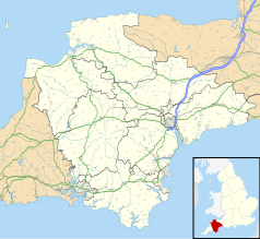
Położenie na mapie Devonu Contains Ordnance Survey data © Crown copyright and database right, CC BY-SA 3.0 | |||||
Położenie na mapie Wielkiej Brytanii (c) Karte: NordNordWest, Lizenz: Creative Commons by-sa-3.0 de | |||||
| Strona internetowa | |||||
Port lotniczy Plymouth-City (ang.: Plymouth City Airport, kod IATA: PLH, kod ICAO: EGHD) – nieczynny krajowy port lotniczy znajdujący się w Plymouth, w hrabstwie Devon, w Anglii.
Historia
Lotnisko zaczęło być budowane w 1925, ale zostało otwarte dopiero w 1931. Jednak pierwszy samolot wyładował tu już w 1923. W 2011 roku lotnisko zostało zamknięte[2].
Przypisy
- ↑ Data and analysis | UK Civil Aviation Authority, www.caa.co.uk [dostęp 2017-11-26] (ang.).
- ↑ This is what could happen to Plymouth City Airport (ang.). Devon Live.
Media użyte na tej stronie
(c) Karte: NordNordWest, Lizenz: Creative Commons by-sa-3.0 de
Location map of the United Kingdom
Symbol lotniska do legendy mapy
Contains Ordnance Survey data © Crown copyright and database right, CC BY-SA 3.0
Map of Devon, UK with the following information shown:
- Administrative borders
- Coastline, lakes and rivers
- Motorways and primary routes
- Urban areas
Equirectangular map projection on WGS 84 datum, with N/S stretched 150%
Geographic limits:
- West: 4.72W
- East: 2.86W
- North: 51.3N
- South: 50.16N
Autor: Eduard Marmet, Licencja: CC BY-SA 3.0
Brymon Airways De Havilland Canada DHC-7-110 Dash 7 G-BRYA at Plymouth Airport


