Port lotniczy Portland
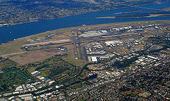
 Widok na port | |||||||
| Państwo | |||||||
|---|---|---|---|---|---|---|---|
| Miejscowość | |||||||
| Typ | cywilne | ||||||
| Właściciel | The Port of Portland | ||||||
| Kod IATA | PDX | ||||||
| Kod ICAO | KPDX | ||||||
| Wysokość | 9 m n.p.m. | ||||||
| Statystyki ruchu (2007) | |||||||
| Liczba operacji | 263 787 | ||||||
| Drogi startowe | |||||||
| |||||||
| Strona internetowa | |||||||
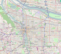
Port lotniczy Portland (ang. Portland International Airport) – międzynarodowe lotnisko położone 6 km na północny wschód od centrum Portland, w stanie Oregon. W 2005 obsłużyło około 13,9 mln pasażerów.
Linie lotnicze i połączenia
Hall A
- Alaska Airlines (Patrz Hall B)
- Horizon Air (Boise, Burbank, Eugene, Fresno, Los Angeles, Medford, Oakland, Ontario, Redding, Redmond/Bend, Reno/Tahoe, Sacramento, Santa Barbara, Santa Rosa, San Francisco, San Jose (CA), Seattle/Tacoma, Spokane, Vancouver)
Hall B
- Alaska Airlines Anchorage, Boston, Denver, Las Vegas, Los Angeles, Long Beach [od 8 lutego], Los Cabos [sezonowo], Oakland, Ontario/LA, Orange County, Palm Springs [sezonowo], Phoenix, Puerto Vallarta [sezonowo], Sacramento, San Diego, San Francisco, San Jose (CA))
- Horizon Air (Patrz Hall A)
Hall C
- Alaska Airlines (Patrz Hall B)
- American Airlines (Chicago-O'Hare [sezonowo], Dallas/Fort Worth)
- Frontier Airlines (Denver)
- Southwest Airlines (Albuquerque, Boise, Chicago-Midway, Denver, Kansas City, Las Vegas, Oakland, Phoenix, Reno/Tahoe, Sacramento, Salt Lake City, San Jose (CA), Spokane)
- US Airways (Charlotte [sezonowo], Las Vegas, Filadelfia, Phoenix)
Hall D
- Continental Airlines (Houston-Intercontinental, Newark)
- Delta Air Lines (Atlanta, Nowy Jork-JFK, Salt Lake City)
- Delta Connection obsługiwane przez SkyWest (Salt Lake City)
- Hawaiian Airlines (Honolulu, Kahului)
- Lufthansa (Frankfurt)
- Northwest Airlines (Amsterdam, Detroit [sezonowo], Honolulu, Minneapolis/St. Paul, Tokio-Narita)
Hall E
- Air Canada
- Air Canada Jazz (Vancouver)
- JetBlue Airways (Long Beach, Nowy Jork-JFK)
- United Airlines (Chicago-O'Hare, Denver, San Francisco, Waszyngton-Dulles)
- United Express obsługiwane przez SkyWest (Denver, Eugene, Klamath Falls, Los Angeles, Medford, North Bend/Coos Bay, Redmond/Bend, San Francisco, Seattle/Tacoma)
Business aviation terminal
- SeaPort Airlines (Seattle-Boeing Field, Pendleton)
Cargo
- Air China Cargo (Pekin, Los Angeles, Szanghaj-Pudong)
- Air Transport International (Toledo, Seattle/Tacoma)
- Ameriflight
- DHL
- ABX Air (Wilmington, Spokane, Riverside)
- FedEx Express (Memphis, Oakland, Indianapolis)
- FedEx Feeder obsługiwane przez Empire Airlines
- UPS Airlines (Rockford, Louisville, Ontario, Spokane)
Media użyte na tej stronie
Autor: Uwe Dedering, Licencja: CC BY-SA 3.0
Location map of the USA (without Hawaii and Alaska).
EquiDistantConicProjection:
Central parallel:
* N: 37.0° N
Central meridian:
* E: 96.0° W
Standard parallels:
* 1: 32.0° N
* 2: 42.0° N
Made with Natural Earth. Free vector and raster map data @ naturalearthdata.com.
Formulas for x and y:
x = 50.0 + 124.03149777329222 * ((1.9694462586094064-({{{2}}}* pi / 180))
      * sin(0.6010514667026994 * ({{{3}}} + 96) * pi / 180))
y = 50.0 + 1.6155950752393982 * 124.03149777329222 * 0.02613325650382181
      - 1.6155950752393982  * 124.03149777329222 *
     (1.3236744353715044  - (1.9694462586094064-({{{2}}}* pi / 180))
      * cos(0.6010514667026994 * ({{{3}}} + 96) * pi / 180))
The flag of Navassa Island is simply the United States flag. It does not have a "local" flag or "unofficial" flag; it is an uninhabited island. The version with a profile view was based on Flags of the World and as a fictional design has no status warranting a place on any Wiki. It was made up by a random person with no connection to the island, it has never flown on the island, and it has never received any sort of recognition or validation by any authority. The person quoted on that page has no authority to bestow a flag, "unofficial" or otherwise, on the island.
Symbol lotniska do legendy mapy
Autor:
Autor: Alexrk2, Licencja: CC BY 3.0
Ta mapa została stworzona za pomocą GeoTools.


