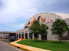
Port lotniczy Rafael Hernandez
 | |||
| Państwo | |||
|---|---|---|---|
| Terytorium nieinkorporowane | |||
| Miejscowość | |||
| Typ | cywilne | ||
| Kod IATA | BQN | ||
| Kod ICAO | TJBQ | ||
| Wysokość | 72 m n.p.m. | ||
| Drogi startowe | |||
| |||
Port lotniczy Rafael Hernandez – port lotniczy, zlokalizowany w portorykańskim mieście Aguadilla.
Linie lotnicze i połączenia
| Linie lotnicze | Połączenia |
|---|---|
| Continental Airlines | Newark |
| JetBlue Airways | New York-JFK, Orlando |
| Pan Am World Airways Dominicana | Punta Cana, Santo Domingo-Las Americas |
| Spirit Airlines | Fort Lauderdale |
Media użyte na tej stronie
Flag of the United States.svg
The flag of Navassa Island is simply the United States flag. It does not have a "local" flag or "unofficial" flag; it is an uninhabited island. The version with a profile view was based on Flags of the World and as a fictional design has no status warranting a place on any Wiki. It was made up by a random person with no connection to the island, it has never flown on the island, and it has never received any sort of recognition or validation by any authority. The person quoted on that page has no authority to bestow a flag, "unofficial" or otherwise, on the island.
The flag of Navassa Island is simply the United States flag. It does not have a "local" flag or "unofficial" flag; it is an uninhabited island. The version with a profile view was based on Flags of the World and as a fictional design has no status warranting a place on any Wiki. It was made up by a random person with no connection to the island, it has never flown on the island, and it has never received any sort of recognition or validation by any authority. The person quoted on that page has no authority to bestow a flag, "unofficial" or otherwise, on the island.
Legenda lotnisko.svg
Symbol lotniska do legendy mapy
Symbol lotniska do legendy mapy
Aguadilla Airport.jpg
Rafael Hernández Airport passenger terminal
Rafael Hernández Airport passenger terminal
USA Puerto Rico location map.svg
Autor: NordNordWest, Licencja: CC BY-SA 3.0
Location map of Puerto Rico, USA
Autor: NordNordWest, Licencja: CC BY-SA 3.0
Location map of Puerto Rico, USA


