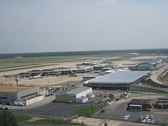
Port lotniczy Richmond
 | |||||||
| Państwo | |||||||
|---|---|---|---|---|---|---|---|
| Miejscowość | |||||||
| Typ | cywilne | ||||||
| Właściciel | Capital Region Airport Commission | ||||||
| Kod IATA | RIC | ||||||
| Kod ICAO | KRIC | ||||||
| Strefa czasowa | UTC -5 | ||||||
| Wysokość | 50,9 m n.p.m. | ||||||
| Drogi startowe | |||||||
| |||||||
| Strona internetowa | |||||||
Port lotniczy Richmond (IATA: RIC, ICAO: KRIC) – port lotniczy położony 8 km na wschód od Richmond, w stanie Wirginia, w Stanach Zjednoczonych.
Linie lotnicze i połączenia
Pirs A
- Air Canada Jazz (Toronto-Pearson) [sezonowo]
- Air Canada obsługiwane przez Air Georgian (Toronto-Pearson) [sezonowo]
- AirTran Airways (Atlanta, Orlando)
- American Airlines (Dallas/Fort Worth)
- American Eagle Airlines (Chicago-O’Hare, Miami)
- US Airways (Charlotte)
- US Airways Express obługiwane przez Air Wisconsin (Boston, Nowy Jork-LaGuardia, Filadelfia)
- US Airways Express obługiwane przez Chautauqua Airlines (Nowy Jork-LaGuardia)
- US Airways Express obługiwane przez Piedmont Airlines (Filadelfia)
- US Airways Express obługiwane przez PSA Airlines (Charlotte, Filadelfia)
- US Airways Express obługiwane przez Republic Airlines (Charlotte, Nowy Jork-LaGuardia, Filadelfia)
Pirs B
- Continental Express obługiwane przez ExpressJet Airlines (Cleveland, Houston-Intercontinental, Newark)
- Delta Air Lines (Atlanta)
- Delta Connection obługiwane przez Atlantic Southeast Airlines (Atlanta)
- Delta Connection obługiwane przez Chautauqua Airlines (Nowy Jork-JFK)
- Delta Connection obługiwane przez Comair (Cincinnati/Northern Kentucky, Detroit, Nowy Jork-JFK)
- Delta Connection obługiwane przez Compass Airlines (Minneapolis/St. Paul)
- Delta Connection obługiwane przez Pinnacle Airlines (Cincinnati/Northern Kentucky, Detroit, Nowy Jork-JFK)
- JetBlue Airways (Boston, Fort Lauderdale, Orlando)
- United Airlines (Chicago-O’Hare)
- United Express obługiwane przez GoJet Airlines (Chicago-O’Hare, Waszyngton-Dulles)
- United Express obługiwane przez Trans States Airlines (Chicago-O’Hare, Waszyngton-Dulles)
Przypisy
Linki zewnętrzne
Media użyte na tej stronie
Autor: Uwe Dedering, Licencja: CC BY-SA 3.0
Location map of the USA (without Hawaii and Alaska).
EquiDistantConicProjection:
Central parallel:
* N: 37.0° N
Central meridian:
* E: 96.0° W
Standard parallels:
* 1: 32.0° N
* 2: 42.0° N
Made with Natural Earth. Free vector and raster map data @ naturalearthdata.com.
Formulas for x and y:
x = 50.0 + 124.03149777329222 * ((1.9694462586094064-({{{2}}}* pi / 180))
      * sin(0.6010514667026994 * ({{{3}}} + 96) * pi / 180))
y = 50.0 + 1.6155950752393982 * 124.03149777329222 * 0.02613325650382181
      - 1.6155950752393982  * 124.03149777329222 *
     (1.3236744353715044  - (1.9694462586094064-({{{2}}}* pi / 180))
      * cos(0.6010514667026994 * ({{{3}}} + 96) * pi / 180))
The flag of Navassa Island is simply the United States flag. It does not have a "local" flag or "unofficial" flag; it is an uninhabited island. The version with a profile view was based on Flags of the World and as a fictional design has no status warranting a place on any Wiki. It was made up by a random person with no connection to the island, it has never flown on the island, and it has never received any sort of recognition or validation by any authority. The person quoted on that page has no authority to bestow a flag, "unofficial" or otherwise, on the island.
Symbol lotniska do legendy mapy
Autor: Ned Russell from Hong Kong, Hong Kong, Licencja: CC BY 2.0
The Richmond International Airport terminal. In the foreground is Concourse A (Air Canada, American, US Airways) and Concourse B (Airtran, Continental, Delta, jetBlue, Northwest, United) is the further away of the two. The terminal building opened in 2007.


