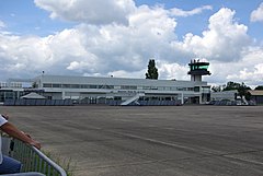
Port lotniczy Tours
 | |||
| Państwo | |||
|---|---|---|---|
| Miejscowość | |||
| Typ | cywilne/wojskowe | ||
| Właściciel | Ministère de la Défense | ||
| Kod IATA | TUF | ||
| Kod ICAO | LFOT | ||
| Strefa czasowa | UTC +1 | ||
| Wysokość | 109 m n.p.m. | ||
| Statystyki ruchu (2010[1]) | |||
| Liczba pasażerów | 123 137 | ||
| Liczba operacji | 7135 | ||
| Drogi startowe | |||
| |||
| Strona internetowa | |||
Port lotniczy Tours (IATA: TUF, ICAO: LFOT) – port lotniczy położony 6 km n północny wschód od Tours, w departamencie Indre i Loara, w regionie centralnym, we Francji.
Linie lotnicze i połączenia
| Linia lotnicza | Kierunek |
|---|---|
| HOP! | Sezonowe czartery: |
| Ryanair | Sezonowo: |
Przypisy
Linki zewnętrzne
Media użyte na tej stronie
Autor: Superbenjamin, Licencja: CC BY-SA 4.0
Blank administrative map of France for geo-location purpose, with regions and departements distinguished. Approximate scale : 1:3,000,000
Symbol lotniska do legendy mapy
Flag of Portugal, created by Columbano Bordalo Pinheiro (1857-1929), officially adopted by Portuguese government in June 30th 1911 (in use since about November 1910). Color shades matching the RGB values officially reccomended here. (PMS values should be used for direct ink or textile; CMYK for 4-color offset printing on paper; this is an image for screen display, RGB should be used.)


