Port lotniczy Wołgograd
 | |||
| Państwo | |||
|---|---|---|---|
| Obwód | |||
| Miejscowość | Wołgograd | ||
| Typ | cywilne | ||
| Właściciel | JSC "Volgograd International Airport" | ||
| Kod IATA | VOG | ||
| Kod ICAO | URWW | ||
| Wysokość | 147 m n.p.m. | ||
| Drogi startowe | |||
| |||
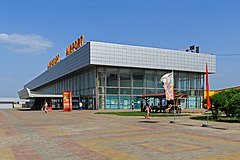
Port lotniczy Wołgograd (IATA: VOG, ICAO: URWW) – port lotniczy położony 15 kilometrów na północny zachód od Wołgogradu, w Rosji.
Linie lotnicze i połączenia
| Linia lotnicza | Kierunek |
|---|---|
| Aerofłot | |
| Nordavia | Sezonowo: |
| Nordwind Airlines | |
| Orenburzhye | |
| Pobeda | |
| RusLine | |
| S7 Airlines | |
| Saratov Airlines |
|
Przypisy
- ↑ Pobeda expands St. Petersburg network in W16 :: Routesonline, www.routesonline.com [dostęp 2017-11-26] (ang.).
Linki zewnętrzne
- Informacje o lotnisku – stan na październik 2006
Media użyte na tej stronie
Autor: Uwe Dedering, Licencja: CC BY-SA 3.0
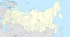
Location map of Russia.
EquiDistantConicProjection : Central parallel :
* N: 54.0° N
Central meridian :
* E: 100.0° E
Standard parallels:
* 1: 49.0° N
* 2: 59.0° N
Made with Natural Earth. Free vector and raster map data @ naturalearthdata.com.
Because the southern Kuril islands are claimed by Russia and Japan, they are shown as disputed. For more information about this see: en:Kuril Islands dispute. These islands are since 1945 under the jurisdiction of the Russian Federation.
Symbol lotniska do legendy mapy
Autor: A.Savin, Licencja: CC BY-SA 3.0
Gumrak Airport in Volgograd, Russia
Autor: Nzeemin, Licencja: CC BY-SA 2.0
Административная карта Волгоградской области, Россия.
- Проекция: Меркатор
- Координаты для GMT: -R41.04/47.57/47.36/51.34
- Инструменты: GMT, Inkscape


