Powódź w Pakistanie (2010)
 | |
| Państwo | |
|---|---|
| Miejsce | |
| Rodzaj zdarzenia | |
| Data | |
| Ofiary śmiertelne | 1781 osób[1] |

Powódź w Pakistanie (2010) – powódź, która miała miejsce w pakistańskiej prowincji Chajber Pasztunchwa na przełomie lipca i sierpnia 2010. Jej przyczyną były intensywne deszcze monsunowe.
W jej wyniku śmierć poniosło 1781 osób, a 14 mln straciło dach nad głową[2]. Pół miliona ludzi zostało wysiedlonych[3].
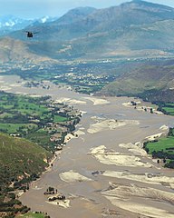
Wiele regionów zostało zupełnie odciętych od świata, szczególnie trudno dostępne pogranicze afgańsko-pakistańskie. Zalane zostały głównie tereny Doliny Swat, w której w 2009 toczyły się ciężkie walki armii pakistańskiej z talibami. Podczas powodzi talibski lider z Doliny Swat Maulana Fazullah wezwał bojowników do powrotu na tereny z których zostali wyparci rok wcześniej[4].
31 lipca odcięta od świata była stolica prowincji – Peszawar. W niektórych miejscach woda sięgała poziomu 5,5 metra[5]. W wyniku powodzi zmiecionych zostało 45 mostów i 3700 domów. Autostrada Karakorum, łącząca Pakistan z Chinami została zamknięta z powodu uszkodzenia mostów[6].
W akcji ratunkowej głównie zaangażowane było wojsko. 30 tysięcy żołnierzy, ponad 40 śmigłowców i 100 łodzi walczyło z żywiołem[7].
Pakistan zaapelował do międzynarodowych darczyńców o pomoc w walce z katastrofą[8]. Ambasada Stanów Zjednoczonych ogłosiła, że USA przekażą 10 mln dol. na pomoc humanitarną, a UE chce na ten cel wydać 30 mln dol[9]. Chiński rząd ogłosił, że zapewni pomoc o wartości 10 milionów juanów. Chiński ambasador odwiedził zalane treny Chajber Pasztunchwa, składając wyrazy ubolewania z powodu tragedii[10]. Pomoc zorganizował także ONZ[6].
Podczas trwania gwałtownych monsunów, 28 lipca pod Islamabadem doszło do katastrofy lotniczej, w której śmierć poniosły 152 osoby.
Zobacz też
Przypisy
- ↑ Czy powódź zatopi prezydenta Pakistanu. [w:] Gazeta Wyborcza [on-line]. Wyborcza.pl, 19 sierpnia 2010. [dostęp 2010-08-21]. (pol.).
- ↑ Pakistan Floods of 2010, [w:] Encyclopædia Britannica [online] [dostęp 2019-01-27] (ang.).
- ↑ Flood deaths pass 400 in Pakistan and Afghanistan. BBC News, 30 lipca 2010. [dostęp 2010-08-02]. (ang.).
- ↑ Katastrofalna powódź w Pakistanie: 1500 ofiar. [w:] IAR [on-line]. Polskie Radio, 2 sierpnia 2010. [dostęp 2010-08-02]. (pol.).
- ↑ 400 Killed in Flooding in Pakistan, Officials Say. The New York Times, 30 lipca 2010. [dostęp 2010-08-02]. (ang.).
- ↑ a b Over 800 dead due to flooding. dawn.com, 1 sierpnia 2010. [dostęp 2010-08-02]. (ang.).
- ↑ Wielka powódź w Pakistanie. rp.pl, 1 sierpnia 2010. [dostęp 2010-08-02]. (pol.).
- ↑ Pakistan floods 'kill 800' people and affect a million. BBC News, 1 sierpnia 2010. [dostęp 2010-08-02]. (ang.).
- ↑ Powódź w Pakistanie. [w:] PAP [on-line]. wiara.pl, 2 sierpnia 2010. [dostęp 2010-08-02]. (pol.).
- ↑ China to provide 10 mn yuan humanitarian aid. dawn.com, 1 sierpnia 2010. [dostęp 2010-08-02]. (ang.).
Media użyte na tej stronie
A Chinook in Company B, Task Force Raptor, 3rd Combat Aviation Brigade, TF Falcon, flies over a bridge destroyed by flood waters, Aug. 11, in the Swat valley, Pakistan. (Photo by U.S. Army Sgt. Monica K. Smith)
Monsoon rains fall in Pakistan every summer, but the rains beginning in late July 2010 were unusually heavy. By August 1, 2010, entire villages were washed away, more than 1,100 people had died, and an estimated 2.5 million people were affected, according to news reports. A shortage of safe drinking water and a possible outbreak of cholera were among the most pressing dangers.
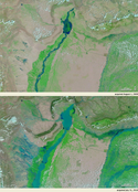
The Moderate Resolution Imaging Spectroradiometer (MODIS) on NASA’s Terra satellite captured these images on July 31, 2010 (bottom), and August 1, 2009 (top). These images show the Indus River in northwestern Pakistan. Both images use a combination of infrared and visible light to increase the contrast between water and land. Water varies in color from electric blue to navy. Vegetation is green and bare ground is pinkish brown. Clouds range in color from nearly white to pale blue-green.
Acquired at the same time of year, the images show the dramatic difference caused by torrential monsoon rains. Flowing roughly north-south the Indus River appears as a braided stream in 2009, with patches of dry or nearly dry ground in the river valley. In 2010, the water level is high enough to cover areas that were dry the previous year. West of the river, long tendrils of standing water extend toward the northwest. Water levels are also significantly higher in tributaries east of the Indus River.
Officials described the flooding in northwestern Pakistan as the worst since 1929. News reports documented some 30,000 residents stranded on rooftops, and some 65 bridges completely washed away. As governments and international aid organizations struggled to assist the flood victims, weather officials forecast more monsoon rains starting August 2, 2010.
MODIS provides daily images, where clouds permit, that enable responders to assess flood conditions over a wide area in a single satellite pass. The MODIS Rapid Response Team provides daily images of this region.

