Powiat Mecklenburgische Seenplatte
| powiat | |||||
| |||||
| Państwo | |||||
|---|---|---|---|---|---|
| Kraj związkowy | |||||
| Siedziba | |||||
| Kod statystyczny | 13 0 71 | ||||
| Powierzchnia | 5 470,35 km² | ||||
| Populacja (31 grudnia 2018) • liczba ludności |
| ||||
| • gęstość | 47 os./km² | ||||
| Tablice rejestracyjne | MSE, AT, DM, MC, MST, MÜR, NZ, RM, WRN, NB | ||||
| Szczegółowy podział administracyjny | |||||
| Liczba gmin | 148 | ||||
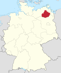
Położenie na mapie Niemiec | |||||
Położenie na mapie Meklemburgii-Pomorza Przedniego | |||||
| Strona internetowa | |||||
| Portal | |||||
Powiat Mecklenburgische Seenplatte (niem. Landkreis Mecklenburgische Seenplatte) – niemiecki powiat leżący w południowej części landu Meklemburgia-Pomorze Przednie. Został utworzony na mocy reformy administracyjnej Meklemburgii-Pomorza Przedniego 4 września 2011 r. z dotychczasowych powiatów Müritz, Mecklenburg-Strelitz, miasta na prawach powiatu Neubrandenburg i Związków Gmin Demmin-Land, Malchin am Kummerower See, Stavenhagen i Treptower Tollensewinkel z powiatu Demmin[2].
Podział administracyjny
W skład powiatu Mecklenburgische Seenplatte wchodzi:
- sześć gmin (niem. amtsfreie Gemeinde)
- 14 związków gmin (niem. Amt)
| Lp. | Nazwa gminy | Ludność (31 grudnia 2018) | Powierzchnia km2 |
|---|---|---|---|
| 1 | Dargun | 4.365 | 117,15 |
| 2 | Demmin | 10.657 | 81,56 |
| 3 | Feldberger Seenlandschaft | 4.433 | 199,57 |
| 4 | Neubrandenburg | 64.086 | 85,65 |
| 5 | Neustrelitz | 20.140 | 138,15 |
| 6 | Waren (Müritz) | 21.061 | 158,39 |
Związki gmin:
| Lp. | Nazwa związku | Ludność (31 grudnia 2018) | Powierzchnia km2 | Liczba gmin |
|---|---|---|---|---|
| 1 | Demmin-Land | 6.815 | 359,59 | 16 |
| 2 | Friedland | 8.406 | 276,32 | 3 |
| 3 | Malchin am Kummerower See | 12.112 | 303,33 | 6 |
| 4 | Malchow | 10.830 | 269,58 | 9 |
| 5 | Mecklenburgische Kleinseenplatte | 7.974 | 311,30 | 4 |
| 6 | Neustrelitz-Land | 7.335 | 446,37 | 11 |
| 7 | Neverin | 8.757 | 222,66 | 12 |
| 8 | Penzliner Land | 6.750 | 212,76 | 4 |
| 9 | Röbel-Müritz | 14.390 | 570,39 | 19 |
| 10 | Seenlandschaft Waren | 9.434 | 502,90 | 14 |
| 11 | Stargarder Land | 9.723 | 205,11 | 6 |
| 12 | Stavenhagen | 11.618 | 305,80 | 13 |
| 13 | Treptower Tollensewinkel | 13.689 | 412,08 | 20 |
| 14 | Woldegk | 6.555 | 290,42 | 7 |
Przypisy
- ↑ Bevölkerung, www.laiv-mv.de [dostęp 2020-02-25].
- ↑ Gesetz- und Verordnungsblatt für Mecklenburg-Vorpommern 2010, Nr 13, s. 366.
Media użyte na tej stronie
Flag of the German district of Mecklenburgische Seenplatte, granted 11 March 2014.
Autor: TUBS
Locator map of Landkreis Mecklenburgische Seenplatte in Mecklenburg-Vorpommern, Germany.
Locator map of Landkreis Mecklenburgische Seenplatte in Mecklenburg-Vorpommern, Germany after county reorganization 2011.


