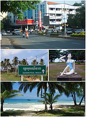
Preăh Sihanŭk
| ||
| Państwo | ||
| Prowincja | Krŏng Preăh Sihanŭk – miasto wydzielone | |
| Populacja (2012) • liczba ludności | 100 856 | |
| Nr kierunkowy | 034 | |
| Kod pocztowy | 18000 | |
Preăh Sihanŭk (khm. ក្រុងព្រះសីហនុ, hist. Kâmpóng Saôm, Sihanoukville) – miasto w południowej Kambodży, nad Zatoką Tajlandzką, stanowi miasto wydzielone; według danych szacunkowych na rok 2012 liczy 100 856 mieszkańców[1] - siódme co do wielkości miasto kraju.
Przypisy
Media użyte na tej stronie
Royal Arms of the Kingdom of Cambodia.
- Depicting: a Golden sword atop two ceremonial bowls, above it is the sacred "Aum", below is a laurel wreath and the Royal Order. The Arms is supported by two creatures, a gajasingha and a singha, they are holding two five-tiered royal umbrellas. Atop the arms is the Royal crown with rays of light emitting from it. Below is a ribbon with the words in Khmer script: ព្រះចៅ ក្រុង កម្ពុជាPreah Chau Krong Kampuchea: "King of the Kingdom of Cambodia".
(c) Wikirictor z angielskiej Wikipedii, CC BY-SA 3.0
town center (top), Ochheuteal Beach road-sign (center-left), sculpture at Independence Beach (center-right), Koh Rong Island coconut grove (bottom)


