Prowincja Amnat Charoen
| Prowincja | |||||
| |||||
| Państwo | |||||
|---|---|---|---|---|---|
| Siedziba | Amnat Charoen | ||||
| Burmistrz | Parinya Panthong | ||||
| Powierzchnia | 3 161,2 km² | ||||
| Populacja (2014) • liczba ludności | 375 380 | ||||
Położenie na mapie | |||||
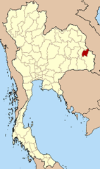
Amnat Charoen (อำนาจเจริญ) – jedna z prowincji (changwat) Tajlandii. Sąsiaduje z prowincjami Ubon Ratchathani, Yasothon i Mukdahan oraz z laotańską prowincją Saravane.
Prowincja znajduje się w dolinie rzeki Mekong.
Media użyte na tej stronie
The national flag of Kingdom of Thailand since September 2017; there are total of 3 colours:
- Red represents the blood spilt to protect Thailand’s independence and often more simply described as representing the nation.
- White represents the religion of Buddhism, the predominant religion of the nation
- Blue represents the monarchy of the nation, which is recognised as the centre of Thai hearts.
Flag of Amnat Charoen Province
Autor: Fine Arts Department (กรมศิลปากร) of Thailand., Licencja: CC BY-SA 4.0
Provincial seal of Amnat Charoen province.
Autor: Ahoerstemeier, Licencja: CC-BY-SA-3.0
Map of Thailand hightlighting Amnat Charoen province


