Prowincja Ang Thong
| Prowincja | |||||
| |||||
| Państwo | |||||
|---|---|---|---|---|---|
| Siedziba | Ang Thong | ||||
| Powierzchnia | 968 km² | ||||
| Populacja (2010) • liczba ludności | 254 292 | ||||
| • gęstość | 262,70 os./km² | ||||
| Plan Ang Thong | |||||
 | |||||
Położenie na mapie | |||||
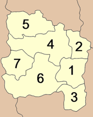
Ang Thong (taj. อ่างทอง) – jedna z centralnych prowincji (changwat) Tajlandii. Sąsiaduje z prowincjami Sing Buri, Lopburi, Ayutthaya i Suphanburi. Dzieli się na siedem dystryktów.
Bibliografia
- Thailand Provinces (ang.). statoids.com. [dostęp 2015-04-30].
Media użyte na tej stronie
The national flag of Kingdom of Thailand since September 2017; there are total of 3 colours:
- Red represents the blood spilt to protect Thailand’s independence and often more simply described as representing the nation.
- White represents the religion of Buddhism, the predominant religion of the nation
- Blue represents the monarchy of the nation, which is recognised as the centre of Thai hearts.
Autor: Ahoerstemeier, Licencja: CC-BY-SA-3.0
Map of the province Ang Thong with the districts (Amphoe) numbered.
- Mueang Ang Thong (เมืองอ่างทอง)
- Chaiyo (ไชโย)
- Pa Mok (ป่าโมก)
- Pho Thong (โพธิ์ทอง)
- Sawaeng Ha (แสวงหา)
- Wiset Chai Chan (วิเศษชัยชาญ)
- Samko (สามโก้)
Autor: Ahoerstemeier, Licencja: CC-BY-SA-3.0
Map of Thailand hightlighting Ang Thong province
Autor: นิติรัฐ เกตุแก้ว, Licencja: CC BY-SA 4.0
ธงพื้นสีเหลืองสด-เขียว แบ่งตามแนวนอน กลางธงเป็นตราประจำจังหวัดรูปรวงข้าวในอ่าง บรรจุอยู่ในรูปวงกลมสีบานเย็น


