Prowincja Bueng Kan
| Prowincja | |||||
 | |||||
| Państwo | |||||
|---|---|---|---|---|---|
| Siedziba | Bueng Kan | ||||
| Powierzchnia | 4 306 km² | ||||
| Populacja (2014) • liczba ludności | 418 566 | ||||
| • gęstość | 97,21 os./km² | ||||
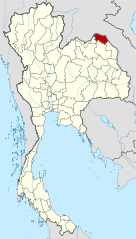
Położenie na mapie | |||||
Bueng Kan (taj. หนองคาย) – jedna z prowincji (changwat) Tajlandii. Sąsiaduje z prowincjami Nakhon Phanom, Sakon Nakhon i Nong Khai oraz z laotańskimi prowincjami Bolikhamxai.
Media użyte na tej stronie
The national flag of Kingdom of Thailand since September 2017; there are total of 3 colours:
- Red represents the blood spilt to protect Thailand’s independence and often more simply described as representing the nation.
- White represents the religion of Buddhism, the predominant religion of the nation
- Blue represents the monarchy of the nation, which is recognised as the centre of Thai hearts.
Official Seal of Bueng Kan Province of Thailand, announced in the Royal Thai Government Gazette in March 2, 2012 (see the sources below).
Flag of Bueng Kan Province
Autor:
- Thailand_Nong_Khai_locator_map.svg: NordNordWest
- Amphoe_Nong_Khai.svg: Hdamm
- derivative work: andy (talk)
Locator map of Bueng Kan Province, Thailand


