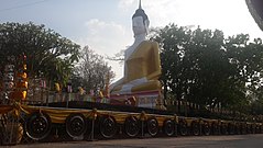
Prowincja Maha Sarakham
| Prowincja | |||||
 | |||||
| Państwo | |||||
|---|---|---|---|---|---|
| Siedziba | Maha Sarakham | ||||
| Burmistrz | Chuan Sirinanphon | ||||
| Powierzchnia | 5 291,7 km² | ||||
| Populacja (2014) • liczba ludności | 960 588 | ||||
Położenie na mapie | |||||
Maha Sarakham (taj. มหาสารคาม) – jedna z prowincji (changwat) Tajlandii. Sąsiaduje z prowincjami Kalasin, Roi Et, Surin, Buri Ram i Khon Kaen.
Kontrola autorytatywna (Podział administracyjny Tajlandii):
Media użyte na tej stronie
Flag of Thailand.svg
The national flag of Kingdom of Thailand since September 2017; there are total of 3 colours:
The national flag of Kingdom of Thailand since September 2017; there are total of 3 colours:
- Red represents the blood spilt to protect Thailand’s independence and often more simply described as representing the nation.
- White represents the religion of Buddhism, the predominant religion of the nation
- Blue represents the monarchy of the nation, which is recognised as the centre of Thai hearts.
Cultural heritage monuments at Kusuntararam Temple.jpg
Autor: Silintrathip, Licencja: CC BY-SA 4.0
This is a photo of a monument in Thailand identified by the ID
Autor: Silintrathip, Licencja: CC BY-SA 4.0
This is a photo of a monument in Thailand identified by the ID
Thailand Maha Sarakham.png
Autor: Ahoerstemeier, Licencja: CC-BY-SA-3.0
Map of Thailand highlighting Maha Sarakham province
Autor: Ahoerstemeier, Licencja: CC-BY-SA-3.0
Map of Thailand highlighting Maha Sarakham province


