Prowincja Pattani
| Prowincja | |||||
 | |||||
| Państwo | |||||
|---|---|---|---|---|---|
| Siedziba | Pattani | ||||
| Burmistrz | Phanu Uthairat | ||||
| Powierzchnia | 1 940,4 km² | ||||
| Populacja (2000) • liczba ludności |
| ||||
| Plan Pattani | |||||
 | |||||
Położenie na mapie | |||||
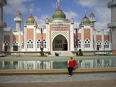
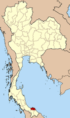
Pattani (taj. ปัตตานี) – jedna z prowincji (changwat) Tajlandii nad zatoką tajlandzką na półwyspie malajskim. Sąsiaduje z prowincjami Narathiwat, Yala i Songkhla.
Zobacz też
Media użyte na tej stronie
The national flag of Kingdom of Thailand since September 2017; there are total of 3 colours:
- Red represents the blood spilt to protect Thailand’s independence and often more simply described as representing the nation.
- White represents the religion of Buddhism, the predominant religion of the nation
- Blue represents the monarchy of the nation, which is recognised as the centre of Thai hearts.
Autor: นิติรัฐ เกตุแก้ว, Licencja: CC BY-SA 4.0
รูปปืนใหญ่พญาตานี บนธงพื้นสีเหลือง-เขียวแบ่งครึ่งตามทางนอน
Autor: Ahoerstemeier, Licencja: CC-BY-SA-3.0
Map of Thailand highlighting Pattani province
Autor: Ahoerstemeier, Licencja: CC-BY-SA-3.0
Map of Pattani province, Thailand, with the districts (Amphoe) numbered.
- Mueang Pattani (อำเภอเมืองปัตตานี)
- Khok Pho (อำเภอโคกโพธิ์)
- Nong Chik (อำเภอหนองจิก)
- Panare (อำเภอปะนาเระ)
- Mayo (อำเภอมายอ)
- Thung Yang Daeng (อำเภอทุ่งยางแดง)
- Sai Buri (อำเภอสายบุรี)
- Mai Kaen (อำเภอไม้แก่น)
- Yaring (อำเภอยะหริ่ง)
- Yarang (อำเภอยะรัง)
- Kapho (อำเภอกะพ้อ)
- Mae Lan (อำเภอแม่ลาน)


