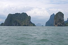
Prowincja Phang Nga
| Prowincja | |||||
© Vyacheslav Argenberg / http://www.vascoplanet.com/, CC BY 4.0 | |||||
| |||||
| Państwo | |||||
|---|---|---|---|---|---|
| Siedziba | Phang Nga | ||||
| Powierzchnia | 4170,0 km² | ||||
| Populacja (2000) • liczba ludności |
| ||||
| Plan Phang Nga | |||||
 | |||||
Położenie na mapie | |||||
Phang Nga (taj. พังงา) – jedna z prowincji (changwat) Tajlandii nad Morzem Andamańskim na Półwyspie Malajskim. Sąsiaduje z prowincjami Ranong, Surat Thani i Krabi. Niedaleko od jej wybrzeża znajduje się wyspa i prowincja Phuket.
Media użyte na tej stronie
The national flag of Kingdom of Thailand since September 2017; there are total of 3 colours:
- Red represents the blood spilt to protect Thailand’s independence and often more simply described as representing the nation.
- White represents the religion of Buddhism, the predominant religion of the nation
- Blue represents the monarchy of the nation, which is recognised as the centre of Thai hearts.
Autor: Ahoerstemeier, Licencja: CC-BY-SA-3.0
Map of Phang Nga province, Thailand, listing the districts.
- Mueang Phangnga
- Ko Yao
- Kapong
- Takua Thung
- Takua Pa
- Khura Buri
- Thap Put
- Thai Mueang
© Vyacheslav Argenberg / http://www.vascoplanet.com/, CC BY 4.0
Phang Nga is a shallow bay with 100+ islands, comprising shallow marine waters and intertidal forested wetlands. Limestone cliffs with caves, collapsed cave systems, and archaeological sites. Karst islands. Phang Nga Bay, Andaman Sea, Thailand.
Autor: Ahoerstemeier, Licencja: CC-BY-SA-3.0
Map of Thailand highlighting Phang Nga province


