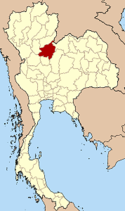
Prowincja Phitsanulok
| Prowincja | |||||
 | |||||
| Państwo | |||||
|---|---|---|---|---|---|
| Siedziba | Phitsanulok | ||||
| Burmistrz | Phiphat Wongsarot | ||||
| Powierzchnia | 10 815,8 km² | ||||
| Populacja (2000) • liczba ludności | 792 678 | ||||
Położenie na mapie | |||||
Phitsanulok (taj. พิษณุโลก) – jedna z prowincji (changwat) Tajlandii. Sąsiaduje z prowincjami Loei, Phetchabun, Phichit, Kamphaeng Phet, Sukhothai i Uttaradit oraz z Laosem (prowincją Xaignabouli).
Media użyte na tej stronie
The national flag of Kingdom of Thailand since September 2017; there are total of 3 colours:
- Red represents the blood spilt to protect Thailand’s independence and often more simply described as representing the nation.
- White represents the religion of Buddhism, the predominant religion of the nation
- Blue represents the monarchy of the nation, which is recognised as the centre of Thai hearts.
Autor: Me.tammalak.nU, Licencja: CC BY-SA 4.0
ธงพื้นสีม่วง กลางธงเป็นตราประจำจังหวัดคือรูปพระพุทธชินราชในวงกลม
Autor: Ahoerstemeier, Licencja: CC-BY-SA-3.0
Map of Thailand highlighting Phitsanulok province
Provincial seal of Phitsanulok Province.


