Prowincja Prachuap Khiri Khan
| Prowincja | |||||
 | |||||
| Państwo | |||||
|---|---|---|---|---|---|
| Siedziba | Prachuap Khiri Khan | ||||
| Burmistrz | Prasong Phithunkitcha | ||||
| Powierzchnia | 6 367,6 km² | ||||
| Populacja (2006) • liczba ludności | 494 299 | ||||
Położenie na mapie | |||||
Prachuap Khiri Khan (taj. ประจวบคีรีขันธ์) – jedna z centralnych prowincji (changwat) Tajlandii. Sąsiaduje z prowincją Phetchaburi od północy i Chumphon od południa oraz z Mjanmą.
Prachuap Khiri Khan jest położony nad zatoką Tajlandzką. Prachuap Khiri Khan jest jednym z głównych regionów turystycznych. Najbardziej popularne miejscowości turystyczne to Hua Hin i Cha Am.
Prachuap Khiri Khan ma dwa duże parki narodowe: Kaeng Kraczan and Sam Roj Jot.
Media użyte na tej stronie
The national flag of Kingdom of Thailand since September 2017; there are total of 3 colours:
- Red represents the blood spilt to protect Thailand’s independence and often more simply described as representing the nation.
- White represents the religion of Buddhism, the predominant religion of the nation
- Blue represents the monarchy of the nation, which is recognised as the centre of Thai hearts.
Autor: Ahoerstemeier, Licencja: CC-BY-SA-3.0
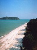
Hat Laem Sala, one of the beaches of the Khao Sam Roi Yod national park, Thailand. Photo taken by User:Ahoerstemeier on January 12 2005.
Autor: Ahoerstemeier, Licencja: CC-BY-SA-3.0
Map of Thailand highlighting Prachuap Khiri Khan province
Flag of Prachuap Khiri Khan Province
Provincial seal of the Prachuap Khiri Khan province, Thailand.


