Prowincja Roi Et
| Prowincja | |||||
 | |||||
| Państwo | |||||
|---|---|---|---|---|---|
| Siedziba | Roi Et | ||||
| Burmistrz | Phinit Phitchayakan | ||||
| Powierzchnia | 8 229,4 km² | ||||
| Populacja (2014) • liczba ludności | 1 308 318 | ||||
Położenie na mapie | |||||
Roi Et (taj. ร้อยเอ็ด) – jedna z prowincji (changwat) Tajlandii. Sąsiaduje z prowincjami Kalasin, Mukdahan, Yasothon, Sisaket, Surin i Maha Sarakham.
]
Kontrola autorytatywna (Podział administracyjny Tajlandii):
Media użyte na tej stronie
Flag of Thailand.svg
The national flag of Kingdom of Thailand since September 2017; there are total of 3 colours:
The national flag of Kingdom of Thailand since September 2017; there are total of 3 colours:
- Red represents the blood spilt to protect Thailand’s independence and often more simply described as representing the nation.
- White represents the religion of Buddhism, the predominant religion of the nation
- Blue represents the monarchy of the nation, which is recognised as the centre of Thai hearts.
Thailand Roi Et.png
Autor: Ahoerstemeier, Licencja: CC-BY-SA-3.0
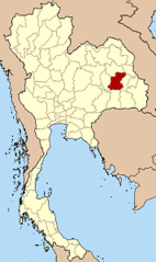
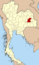
Map of Thailand highlighting Roi Et province
Autor: Ahoerstemeier, Licencja: CC-BY-SA-3.0
Map of Thailand highlighting Roi Et province
Phra Phuttha Rattana.jpg
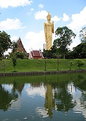
Phra Phuttha Rattana Mongkhon Maha Muni or Luang Pho Yai, Wat Burapha Phiram, Roi Et Province.
Phra Phuttha Rattana Mongkhon Maha Muni or Luang Pho Yai, Wat Burapha Phiram, Roi Et Province.


