Prowincja Sa Kaeo
| Prowincja | |||
 | |||
| |||
| Państwo | |||
|---|---|---|---|
| Siedziba | Sa Kaeo | ||
| Powierzchnia | 7 195 km² | ||
| Populacja (2010) • liczba ludności | 555 961 | ||
| • gęstość | 77,27 os./km² | ||
Położenie na mapie | |||
Sa Kaeo (taj. สระแก้ว) – jedna z prowincji (changwat) Tajlandii. Sąsiaduje z prowincjami Chanthaburi, Chachoengsao, Prachin Buri, Nakhon Ratchasima i Buri Ram. Prowincja graniczy z Kambodżą.
Bibliografia
- Thailand Provinces (ang.). statoids.com. [dostęp 2015-04-30].
Media użyte na tej stronie
The national flag of Kingdom of Thailand since September 2017; there are total of 3 colours:
- Red represents the blood spilt to protect Thailand’s independence and often more simply described as representing the nation.
- White represents the religion of Buddhism, the predominant religion of the nation
- Blue represents the monarchy of the nation, which is recognised as the centre of Thai hearts.
Autor: Ahoerstemeier, Licencja: CC-BY-SA-3.0
Map of Thailand highlighting Sa Kaeo province
Autor: นิติรัฐ เกตุแก้ว, Licencja: CC BY-SA 4.0
ธงสองแถบตามแนวนอน เหลือง-เขียว ตรงกลางมีตราประจำจังหวัดเป็นรูปพระพุทธรูปปางสรงสรีระ ประทับยืนบนดอกบัว ด้านหลังเป็นภาพพระอาทิตย์ยามรุ่ง ตอนกลางเป็นภาพปราสาทเขาน้อยสีชมพู
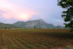
Photograph showing the countryside and mountain range located in the Srakaeo Province of Thailand, along the Thai and Cambodian border, April 10, 2008.


