Prowincja Surat Thani
| Prowincja | |||||
 | |||||
| Państwo | |||||
|---|---|---|---|---|---|
| Siedziba | Surat Thani | ||||
| Burmistrz | Niwat Sawatkaeo | ||||
| Powierzchnia | 12 891,5 km² | ||||
| Populacja (2000) • liczba ludności | 961 800 | ||||
| Plan Surat Thani | |||||
 | |||||
Położenie na mapie | |||||
Surat Thani (taj. สุราษฎร์ธานี) – jedna z prowincji (changwat) Tajlandii nad Zatoką Tajlandzką na półwyspie malajskim. Sąsiaduje z prowincjami Chumphon, Nakhon Si Thammarat, Krabi, Phang Nga i Ranong.
Media użyte na tej stronie
The national flag of Kingdom of Thailand since September 2017; there are total of 3 colours:
- Red represents the blood spilt to protect Thailand’s independence and often more simply described as representing the nation.
- White represents the religion of Buddhism, the predominant religion of the nation
- Blue represents the monarchy of the nation, which is recognised as the centre of Thai hearts.
Autor: Ahoerstemeier, Licencja: CC-BY-SA-3.0
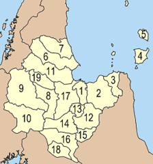
Map of the province Surat Thani with the districts (Amphoe) numbered.
- Mueang Surat Thani (อำเภอเมืองสุราษฎร์ธานี)
- Kanchanadit (อำเภอกาญจนดิษฐ์)
- Don Sak (อำเภอดอนสัก)
- Ko Samui (อำเภอเกาะสมุย)
- Ko Pha Ngan (อำเภอเกาะพะงัน)
- Chaiya (อำเภอไชยา)
- Tha Chana (อำเภอท่าชนะ)
- Khiri Ratthananikhom (อำเภอคีรีรัฐนิคม)
- Ban Ta Khun (อำเภอบ้านตาขุน)
- Phanom (อำเภอพนม)
- Tha Chang (อำเภอท่าฉาง)
- Ban Na San (อำเภอบ้านนาสาร)
- Ban Na Doem (อำเภอบ้านนาเดิม)
- Khian Sa (อำเภอเคียนซา)
- Wiang Sa (อำเภอเวียงสระ)
- Phrasaeng (อำเภอพระแสง)
- Phunphin (อำเภอพุนพิน)
- Chai Buri (อำเภอชัยบุรี)
- Wiphawadi (sub-district) (กิ่งอำเภอวิภาวดี)
Autor: Ahoerstemeier, Licencja: CC-BY-SA-3.0
Map of Thailand highlighting the province Surat Thani
Autor: นิติรัฐ เกตุแก้ว, Licencja: CC BY-SA 4.0
Flag of Surat Thani Province
Autor: Dan Taylor z London, UK, Licencja: CC BY 2.0
Ao Thong Nai Pan, Koh Phangan, Surat Thani, Thailand


