Prowincja Uthai Thani
| Prowincja | |||||
 | |||||
| Państwo | |||||
|---|---|---|---|---|---|
| Siedziba | Uthai Thani | ||||
| Burmistrz | Udom Phuasakun | ||||
| Powierzchnia | 6 730,2 km² | ||||
| Populacja (2000) • liczba ludności | 304 122 | ||||
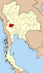
Położenie na mapie | |||||
Uthai Thani (อุทัยธานี) – jedna z prowincji (changwat) Tajlandii. Sąsiaduje z prowincjami Nakhon Sawan, Chai Nat, Suphan Buri, Kanchanaburi i Tak.
Kontrola autorytatywna (Podział administracyjny Tajlandii):
Media użyte na tej stronie
Flag of Thailand.svg
The national flag of Kingdom of Thailand since September 2017; there are total of 3 colours:
The national flag of Kingdom of Thailand since September 2017; there are total of 3 colours:
- Red represents the blood spilt to protect Thailand’s independence and often more simply described as representing the nation.
- White represents the religion of Buddhism, the predominant religion of the nation
- Blue represents the monarchy of the nation, which is recognised as the centre of Thai hearts.
Wat Chantaram02.JPG
Autor: Meneerke bloem, Licencja: CC BY-SA 3.0
Wat Chantaram (or Wat Tha Sung, Uthai Thani)
Autor: Meneerke bloem, Licencja: CC BY-SA 3.0
Wat Chantaram (or Wat Tha Sung, Uthai Thani)
Flag of Uthai Thani Province.jpg
Flag of Uthai Thani Province
Flag of Uthai Thani Province
Thailand Uthai Thani.png
Autor: Ahoerstemeier, Licencja: CC-BY-SA-3.0
Map of Thailand highlighting Uthai Thani province
Autor: Ahoerstemeier, Licencja: CC-BY-SA-3.0
Map of Thailand highlighting Uthai Thani province
Seal Uthaithani.png
Seal of Uthai Thani Province of Thailand in accordance to the announcement for official seals of Thai province, print in the Royal Thai Government Gazette in 2004.
Seal of Uthai Thani Province of Thailand in accordance to the announcement for official seals of Thai province, print in the Royal Thai Government Gazette in 2004.


