Prudential (przedsiębiorstwo)
 1 Angel Court, siedziba przedsiębiorstwa | |
| Państwo | |
|---|---|
| Siedziba | |
| Adres | 1 Angel Court, London EC2R 7HJ |
| Data założenia | 30 maja 1848[1] |
| Forma prawna | public limited company |
| Zatrudnienie | 23 tys.[2] |
| Giełda | LSE, NYSE, SEHK, SGX |
| Symbol akcji | |
| Dane finansowe (2021[3]) | |
| Przychody |
|
| Wynik operacyjny |
|
| Wynik netto |
|
| Aktywa |
|
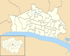
Położenie na mapie City of London Contains Ordnance Survey data © Crown copyright and database right, CC BY-SA 3.0 | |
Położenie na mapie Wielkiej Brytanii (c) Karte: NordNordWest, Lizenz: Creative Commons by-sa-3.0 de | |
Położenie na mapie Wielkiego Londynu Contains Ordnance Survey data © Crown copyright and database right, CC BY-SA 3.0 | |
| Strona internetowa | |
Prudential plc – brytyjskie przedsiębiorstwo ubezpieczeniowe z siedzibą w Londynie. Zostało założone w 1848 roku pod nazwą „The Prudential Mutual Assurance Investment and Loan Association”[1].
Przedsiębiorstwo jest notowane na giełdach papierów wartościowych w Londynie (wchodząc w skład FTSE 100[4]), Hongkongu, Nowym Jorku i Singapurze[5].
Przypisy
- ↑ a b Timeline. prudentialplc.com. [dostęp 2022-10-31]. (ang.).
- ↑ Prudential Plc : Everything you need to know. insurancebusinessmag.com. [dostęp 2022-10-31]. (ang.).
- ↑ IFRS disclosure and additional financial information. Prudential plc 2021 results. International Financial Reporting Standards (IFRS) basis results. prudentialplc.com. [dostęp 2022-10-31]. (ang.).
- ↑ Prudential plc Annual Report 2019. prudentialplc.com. [dostęp 2022-10-31]. (ang.).
- ↑ Singapore Exchange welcomes Prudential. sbr.com.sg. [dostęp 2022-10-31]. (ang.).
Linki zewnętrzne
- Oficjalna strona (ang.)
Media użyte na tej stronie
(c) Karte: NordNordWest, Lizenz: Creative Commons by-sa-3.0 de
Location map of the United Kingdom
Contains Ordnance Survey data © Crown copyright and database right, CC BY-SA 3.0
Map of Greater London, UK with the following information shown:
- Administrative borders
- Coastline, lakes and rivers
- Roads and railways
- Urban areas
The data includes both primary routes and railway lines.
Equirectangular map projection on WGS 84 datum, with N/S stretched 160%
Geographic limits:
- West: 0.57W
- East: 0.37E
- North: 51.72N
- South: 51.25N
Icon representing a decrease, consisting of a red-colored, down-pointing triangle.
Contains Ordnance Survey data © Crown copyright and database right, CC BY-SA 3.0
Blank map of the City of London, showing electoral wards.
Equirectangular map projection on WGS 84 datum, with N/S stretched 160%
Geographic limits:
- West: 0.12W
- East: 0.07W
- North: 51.525N
- South: 51.5N


