Przylądek Dieżniowa
 | |
| Państwo | |
|---|---|
| Okręg autonomiczny | |
| Rodzaj obiektu | przylądek |
Przylądek Dieżniowa (ros. мыс Дежнёва, mys Dieżniowa) – przylądek w Rosji; najdalej na wschód wysunięty punkt Azji; współrzędne geograficzne 66°05′N 169°40′W/66,083333 -169,666667.
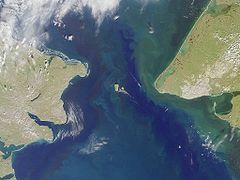
Leży na wschodnim krańcu Półwyspu Czukockiego nad Cieśniną Beringa pomiędzy Morzem Czukockim a Morzem Beringa. Po przeciwnej stronie Cieśniny znajduje się Przylądek Księcia Walii na półwyspie Seward (Alaska).
Przylądek nazwano na cześć XVII-wiecznego podróżnika rosyjskiego, Siemiona Iwanowicza Dieżniowa, badacza tamtego regionu.
Linki zewnętrzne
Media użyte na tej stronie
Bering strait, image taken by MISR satellite.
With the Seward Peninsula of Alaska to the east, and Chukotskiy Poluostrovof Siberia to the west, the Bering Strait separates the United States and the Russian Federation by only 90 kilometers. It is named for Danish explorer Vitus Bering, who spotted the Alaskan mainland in 1741 while leading an expedition of Russian sailors. This view of the region was captured by MISR's vertical-viewing (nadir) camera on August 18, 2000 during Terra orbit 3562.
The boundary between the US and Russia lies between Big and Little Diomede Islands, which are visible in the middle of the Bering Strait. The Arctic Circle, at 66.5 degrees north latitude, runs through the Arctic Ocean in the top part of this image. This circle marks the southernmost latitude for which the Sun does not rise above the horizon on the day of the winter solstice. At the bottom of this image is St. Lawrence Island. Situated in the Bering Sea, it is part of Alaska and home to Yupik Eskimos.
MISR was built and is managed by NASA's Jet Propulsion Laboratory, Pasadena, CA, for NASA's Office of Earth Science, Washington, DC. The Terra satellite is managed by NASA's Goddard Space Flight Center, Greenbelt, MD. JPL is a division of the California Institute of Technology. For more information: http://www-misr.jpl.nasa.govAutor: Das steinerne Herz, Licencja: CC BY-SA 3.0
Chukotka_Autonomous_Okrug_relief_location_map
Autor: Uwe Dedering, Licencja: CC BY-SA 3.0
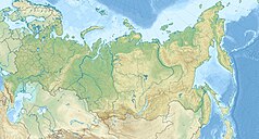
Location map of Russia.
EquiDistantConicProjection : Central parallel :
* N: 54.0° N
Central meridian :
* E: 100.0° E
Standard parallels:
* 1: 49.0° N
* 2: 59.0° N
Made with Natural Earth. Free vector and raster map data @ naturalearthdata.com.


