Qrendi
 | |||||
| Państwo | |||||
|---|---|---|---|---|---|
| Kod ISO 3166-2 | MT-44[1] | ||||
| Burmistrz | David Michael Schembri | ||||
| Powierzchnia | 4,9 km²[2] | ||||
| Populacja (2014) • liczba ludności | 2 752[3] | ||||
| • gęstość | 562 os./km² | ||||
| Kod pocztowy | QRD | ||||
Adres urzędu: 7, Triq il-Knisja,Qrendi QRD 1103 Malta | |||||
Położenie na mapie Malty | |||||
| 35°50′03″N 14°27′32″E/35,834167 14,458889 | |||||
| Strona internetowa | |||||
Qrendi – jedna z jednostek administracyjnych na Malcie. W 2014 roku jednostce mieszkało 2752 osób[3]. W latach 40. XX wieku istniała tutaj baza lotnictwa brytyjskiego RAF Krendi.
Turystyka
- Mnajdra, ruiny neolitycznych świątyń
- Ħaġar Qim, ruiny neolitycznej świątyni
- Kościół Wniebowzięcia Najświętszej Maryi Panny z 1712 roku
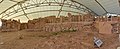
- Kościół św. Mateusza (Church of St Matthew) z 1682 roku, wraz z XI wieczną kapliczką
- Kościół Naszego Zbawiciela (Our Saviour's Church)
- Kościół św. Katarzyny "Tat-Torba" (St Catherine 'Tat-Torba' Church) z 1626 roku
- Kaplica Matki Bożej Łaskawej (Our Lady of Graces Chapel) z 1658 roku
- Kaplica św. Anny (St Anne's Chapel)
- Sanktuarium Matki Bożej Miłosierdzia (Shrine of Our Lady of Mercy) z 1650 roku
- Wieża Cavalier z 1605 roku
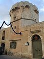
- Wieża Ħamrija z 1659 roku
- Wieża Sciuta z 1638 roku
- Blue Grotto (Błękitna Grota), jaskinia
- Maqluba, lej krasowy
- Um El Faroud, wrak okrętu, atrakcja dla nurków
Mnajdra

Ħaġar Qim

Kościół Wniebowzięcia Najświętszej Maryi Panny

Kościół św. Mateusza
Kościół Naszego Zbawiciela
Kaplica Matki Bożej Łaskawej
Kaplica św. Anny
Sanktuarium Matki Bożej Miłosierdzia
Wieża Cavalier

Wieża Ħamrija

Wieża Sciuta
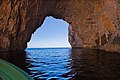
Wnętrze Błękitnej Groty

Maqluba
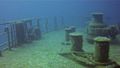
Wrak okrętu Um El Faroud
Sport
W miejscowości funkcjonuje klub piłkarski Qrendi F.C., powstały w 1955 roku. Klub obecnie gra w Maltese First Division, drugiej maltańskiej lidze.
Przypisy
- ↑ ISO 3166-2 MT - Międzynarodowa Organizacja Normalizacyjna, 2015
- ↑ Localities of Malta - statoids.com
- ↑ a b Estimated Population by Locality 31st March, 2014 (ang.). gov.mt.
| wyspa Malta Rady lokalne |
|
|---|---|
| wyspa Malta Komitety administracyjne |
|
| wyspa Gozo Rady lokalne | |
| wyspa Gozo Komitety administracyjne |

Media użyte na tej stronie


(c) NickGeorge1993 z angielskiej Wikipedii, CC BY-SA 3.0
The chapel of St Anne in Qrendi Malta.
Autor: TUBS
Location of local council XY (see filename) in Malta

Autor: Zairon, Licencja: CC BY-SA 3.0
Facade of the Parish Church, Qrendi
Coat of arms of Malta.

(c) NickGeorge1993 z angielskiej Wikipedii, CC BY-SA 3.0
The church of Our Lady of Mercy located in Qrendi Malta.

(c) NickGeorge1993 z angielskiej Wikipedii, CC BY-SA 3.0
Chapel of Our Lady of Graces in Qrendi Malta.

Autor: dodecupido, Licencja: CC BY-SA 1.0
This media is about Maltese cultural property with inventory number 25.

Autor: G.Mannaerts, Licencja: CC BY-SA 4.0
vu panoramique d'ensemble du temple de Mnajdra, Malte

Flag of Qrendi, Malta

Autor: Frank Vincentz, Licencja: CC BY-SA 3.0
Il-Maqluba, Misraħ tal-Maqluba in Qrendi, Malta


(c) Joseph.j.zarb at the English Wikipedia, CC-BY-SA-3.0
Hamrija Tower closer view, photo taken from a breach in the rubble wall directly to the east of the tower. Photo by Joseph J. Zarb
Autor: Enrique Íñiguez Rodríguez (Qoan)
This work was created by Enrique Íñiguez Rodríguez (Qoan). You are free to use it for any purpose as long as you credit me properly (e.g. © Enrique Íñiguez Rodríguez (CC-BY-SA); other variants are acceptable, let me know if in doubt).
Reuse:
- If you use this image outside of Wikimedia projects, I would be happy to hear from you.
- If you use this image in a printed publication, I would love to get a copy for my archives.
- If you're unsure about how you can use this picture.
- If you have any questions about attribution or other topics related to my files.
Qrendi.


Autor: Frank Vincentz, Licencja: CC BY-SA 3.0
Kappella ta' San Mattew tal-Maqluba at Misraħ tal-Maqluba / Triq Wied iż-Żurrieq in Qrendi, Malta

Autor: Continentaleurope, Licencja: CC BY-SA 4.0
This media is about Maltese cultural property with inventory number 01429.

(c) NickGeorge1993 z angielskiej Wikipedii, CC BY-SA 4.0
The chapel of Our Saviour in Qrendi Malta.

Autor: Bengt Nyman, Licencja: CC BY 2.0
The Blue Grotto in Malta seen from the sea

Autor: Frank Vincentz, Licencja: CC BY-SA 3.0
Torri ta' Xutu, Triq Congreve in Wied iz Żurrieq in Qrendi, Malta