Quimper
| gmina | |||
 Stare miasto | |||
| |||
| Państwo | |||
|---|---|---|---|
| Region | |||
| Departament | |||
| Okręg | |||
| Kod INSEE | 29232 | ||
| Mer | Bernard Poignant | ||
| Powierzchnia | 84,43 km² | ||
| Populacja (1990) • liczba ludności |
| ||
| • gęstość | 704 os./km² | ||
| Kod pocztowy | 29000 | ||
Położenie na mapie Finistère  | |||
Położenie na mapie Francji  | |||
Położenie na mapie Bretanii  | |||
| Strona internetowa | |||
| Portal | |||
.png)
Quimper (bret. Kemper) – miejscowość i gmina w północno-zachodniej Francji, w regionie Bretania. Miasto jest prefekturą departamentu Finistère.
Według danych na rok 1990 gminę zamieszkiwało 59 437 osób, a gęstość zaludnienia wynosiła 704 osoby/km² (wśród 1269 gmin Bretanii Quimper plasuje się na 3. miejscu pod względem liczby ludności, natomiast pod względem powierzchni na miejscu 5.).
Miasto leży w pobliżu ujścia rzeki Odet do Oceanu Atlantyckiego.
W mieście znajduje się stacja kolejowa Gare de Quimper.
Zabytki
Quimper zostało sklasyfikowane jako „miasto sztuki i historii”. W mieście znajduje się katedra Saint-Corentin, zbudowana w stylu gotyku bretońskiego, wzniesiona w 1239 roku na fundamentach starej katedry romańskiej. W dzielnicy Locmaria znajduje się kościół romański z XII wieku, jest to jeden z najstarszych zabytków w departamencie Finistère.
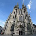
Katedra, fasada
 © Raimond Spekking / CC BY-SA 4.0 (via Wikimedia Commons)
Wnętrze katedry

Okolice katedry

Stare miasto
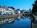
Odet w Quimper
Współpraca
 Limerick, Irlandia
 Remscheid, Niemcy
 Falkirk, Szkocja
 Orense, Hiszpania
 Yantai, Chińska Republika Ludowa
 Foggia, Włochy
Bibliografia
- Francuski urząd statystyczny. (fr.).
Media użyte na tej stronie
Autor: Superbenjamin, Licencja: CC BY-SA 4.0
Blank administrative map of France for geo-location purpose, with regions and departements distinguished. Approximate scale : 1:3,000,000
.svg)


Autor: Pedro A. Gracia Fajardo, escudo de Manual de Imagen Institucional de la Administración General del Estado, Licencja: CC0
Flaga Hiszpanii


Autor: Lexicon and GwenofGwened, Licencja: CC BY-SA 4.0
Traditional flag of Brittany

© Raimond Spekking / CC BY-SA 4.0 (via Wikimedia Commons)
Cathédrale Saint-Corentin de Quimper
Autor: Eric Gaba (Sting - fr:Sting), Licencja: CC BY-SA 3.0
Blank administrative map of the region of Bretagne, France, for geo-location purpose, with distinct boundaries for regions, departments and arrondissements.

Autor: Eric Gaba (Sting - fr:Sting), Licencja: CC BY-SA 3.0
Blank administrative map of the department of Finistère, France, for geo-location purpose, with distinct boundaries for departments and arrondissements.

De Odet in Quimper
Quimper : Altstadt
.svg)
Description: Map for localisazion of cantons of Bretagne region in France
Source: made by Hervé Tigier in april 2005 from another large map (published in 1990)
Autor: Tom dl, Licencja: CC BY-SA 3.0
The main side of the cathedral, as seen from the town square