Qullissat
 | |
| Państwo | |
|---|---|
| Terytorium zależne | |
| Gmina | Qaasuitsup |
| Populacja (2005) • liczba ludności |
|
Położenie na mapie Grenlandii  | |
| Portal | |
Qullissat – opuszczona w 1972 roku górnicza osada w zachodniej Grenlandii, w gminie Qaasuitsup, na północno-wschodnim brzegu wyspy Disko (Qeqertarsuaq).
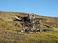
Stare kopalnie

Kościół
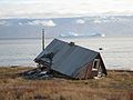
Opuszczony dom
Linki zewnętrzne
- population-statistics.com. population-statistics.com. [zarchiwizowane z tego adresu (2011-07-15)].
![]()
Media użyte na tej stronie


Greenland edcp location map.svg
Autor: Uwe Dedering, Licencja: CC BY-SA 3.0
Location map of Greenland.
Autor: Uwe Dedering, Licencja: CC BY-SA 3.0
Location map of Greenland.
- Projection: EquiDistantConicProjection.
- Area of interest:
- N: 85.0° N
- S: 59.0° N
- W: -75.0° E
- E: -10.0° E
- Projection center:
- NS: 72.0° N
- WE: -42.5° E
- Standard parallels:
- 1: 64.0° N
- 2: 80.0° N
- GMT projection: -JD-42.5/72/64/80/20c
- GMT region: -R-60.16/57.61/24.5/79.91r
- GMT region for grdcut: -R-120.24/57.61/24.5/85.78r
- Made with Natural Earth. Free vector and raster map data @ naturalearthdata.com.

Illullissat - Kirche aus Qllissat.jpg
Autor: JuBo14, Licencja: CC BY-SA 3.0
Ilulissat: Church from Qllissat
Autor: JuBo14, Licencja: CC BY-SA 3.0
Ilulissat: Church from Qllissat
